Another Town in the 200 Club

Thursday, March 25, 2026

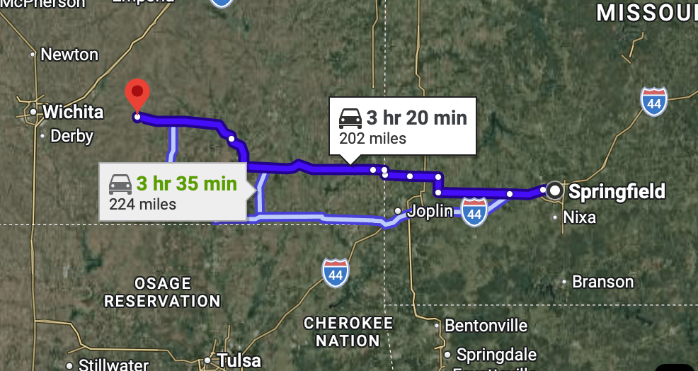
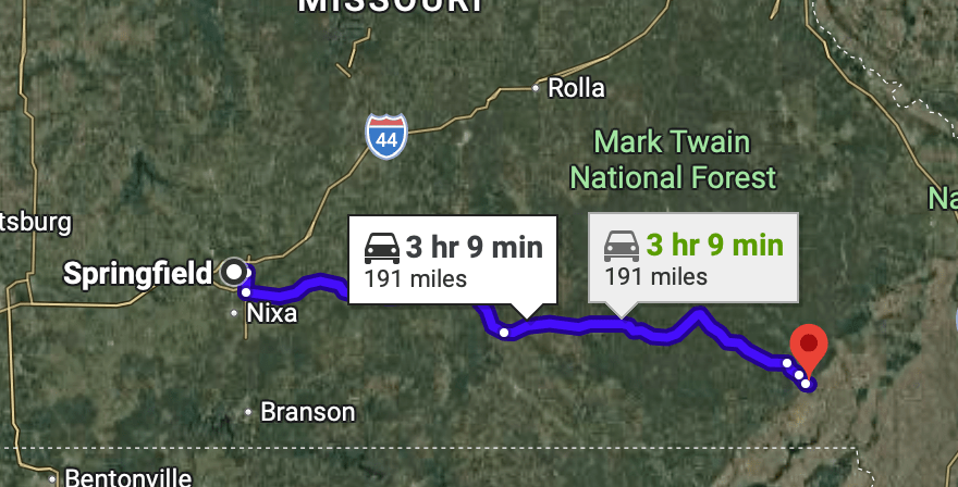
Poplar Bluff MO is a mere 200 miles from Springfield and on the route home so we put it in the 200 mile traveled club and stop. Some weather may be coming Into the area and we don’t want to get caught traveling in bad weather. We’ll stay In Poplar Bluff for two nights at the Camelot RV Park. The park is pretty big and the sites are build on the undulating hillsides. The owners are super nice. We like this park.

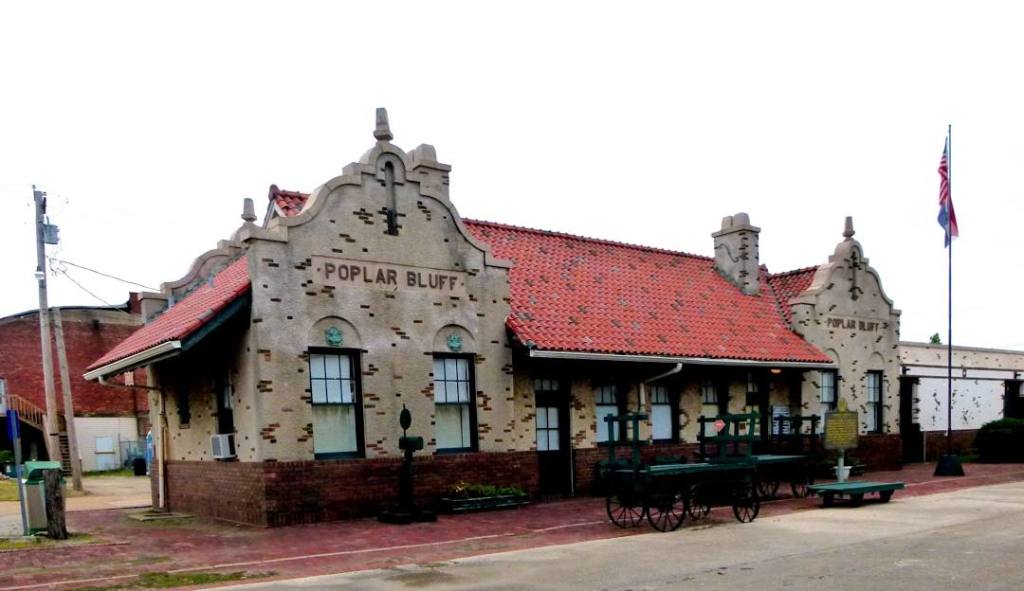
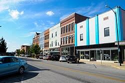
We went downtown today. It was nothing special. It’s the seat of Butler County and is home to 16,225 souls. The area was French held until 1771, when it was ceded to Spain who returned the area back to France in 1802. It then had no permanent European influence until 1819 when the first white family moved into the area. It seemed like nobody wanted it…………… A tornado leveled the town in 1927, killing 92. March 15th of 2025 Poplar Bluff was hit by another tornado, this time killing one person.

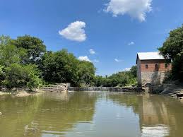
Poplar Bluff is located on the Black River and takes its name from a bluff that overlooks the river.  When first settled, the bluff was covered with tulip poplar trees in one of their few abundant populations west of the Mississippi River.

Tomorrow we’ll decide on whether to skedaddle home or spend one more day on the road. Standby to standby

Springfield, MO

Wednesday March 24, 2026

In keeping with our policy this entire trip we attempt to drive around 200 miles per travel day and today is no exception. Beaumont was a very interesting place for its past and now it’s just a quirky little settlement- but worth the stop. If we didn’t stop how would we have known about this place. We continue east, then south on US400, a very pleasant road to travel.

Most people think Kansas is flat. Not true, I counted at least one hill. The farther east in the state the more hills and the greener the landscape. We pass Fredonia (2151 souls) which is located just off US400 in southeast Kansas between Wichita and Joplin. Fredonia is located at the rim of the scenic Flint Hills, an area rich with recreational opportunities. The river valleys, range land, and wooded hills offer exceptional hunting, outdoor living, and trail riding. The town was based on the railroad, coal, and soy bean processing.

Springfield (169, 176 souls) is by known several nicknames- the Queen of the Ozarks, , the birthplace of Route 66 and the Buckle of the Bible Belt. It’s also home to Bass Pro Shops and O’Reilly Auto Parts. An airport large enough for jet planes is in town. I assume most passengers would be going to Branson MO which is less than 44 miles away.

We drop down to MO96 and take it to Springfield MO. We are staying at the Springfield/ Rout 66 KOA. I don’t usually like to stay at KOA’s as most are dated, and spacing of the sites are toonarrow. But this KOA breaks the mold. The sites are long and wide with deciduous trees in between. There are at least three pet areas and a giant multi-use grassy field for anyone’s enjoyment. There is a kiddy play area provided. The only drawback is the nearby rail had at least 6 trains go by while we were there- but we are used to that. It’s a very pretty park.

Springfield had four country western TV shows broadcast during the 1950’s and 1960’s. I remember one- the Eddie Arnold Show. Many of the biggest names in Country Western frequented the shows or lived in Springfield at the time.

It also has a unique cave, Cantastic Caverns, that has passenger cars that drive through it.

We’ll be heading down to Poplar Bluff for a couple of nights to let a weather system blow through. See you there.

Beaumont, KS

Monday March 23, 2026

We left Dodge City having around 800 miles to home. We are sneaking up on our destination 200 miles at a time. We enjoy traveling much more when we are on the road 5 hours rather than more. And if the wind is blowing I don’t enjoy countersteering into the wind to keep the RV pointed straight down the road. It’s just tiring to do that 4 to 5 hours at a time.

Anyhoo, we are on US 400 which is a very nice two lane road. It’s smooth with wide shoulders and the annoying rumble strip is placed outside the fog line. I like because when the wind blows it may push the rig over a little and onto the fog line where a lot of rumble strips are placed…… brrrrrrp goes the tires on the strip.

We reach Wichita. We’ve been cringing to cross this city as we have no idea if we have to do it on surface streets or something better. It turns out Kansas has a better idea and supplies us with a roadway similar to a West Coast Freeway. We cross through Wichita with little problem and not much traffic which is quite wonderful considering this city’s population is 397,532 souls. In fact, the major annoyance was the multiple traffic signals before and after reaching the “freeway” section of US 400.

We are out in the country and wondering who would build a hotel this far away from a city. We pull into Beaumont, an almost ghost town feeling place. The hotel is located in a two story building with a cafe on the first. The “town” has 36 souls living there.

May be an image of text

The town site was first a stop on the stagecoach route between Fredonia and Wichita. In 1879 Edwin and Emma Russell built the Summit Hotel, later renamed as the Beaumont Hotel. I

n 1885 the St. Louis and San Francisco Railroad, better known as the Frisco, established Beaumont as a railroad town. One line of tracks ran east and west, connecting St. Louis with Wichita. A spur was added later going south from Beaumont though Latham and on to the Oklahoma border.] 

Sometimes its easier tell a story with pictures, so here goes………..

A roundhouse was built in 1890 across from the Summit Hotel, and employed 90 people. The water tower, built in 1885, stands across from the hotel and is on the National Register of Historic Places. Because of the rich bluestem grass, the area was used as staging area to ship cattle back east.

May be an image of text

\

May be an image of text that says 'BEAUMONT'
May be an image of text

What Place Was Made Famous By Gunsmoke?

March 21 and 22, 2026

So our next stop is only 208 miles away from La Junta and in the state of Kansas. Any Guesses? That’s right, we are going to a place the TV show Gunsmoke made famous- Dodge City. Made famous by Wyatt Earp, Doc Holiday, and in the TV show six foot 7 inch James Arness as Marshal Matt Dillon and don’t forget Miss Kitty. This town once featured 17 saloons, some with elevated stages so customers could watch Can Can Girls dance.

But the city wasn’t built on Marshal Dillon, more on the arrival of the Atcheson, Topeka and Santa Fe Railroad. The Santa Fe Trail also brought folks wanting to start anew. Not that there weren’t characters to enhance the legend of Dodge City. There’s “Big Nose” Kate Elder who got her name not from physical attributes but referred to being “nosey”. And then there was “Ham” Bell who opened the Elephant Livery and Corral which was one of the first businesses to open here. He also became Undertaker, Deputy Marshal and Ford County Sheriff.

May be an image of text that says 'GENERAL OUTFITTING ИKCAH_ G.M.Hoover G.M. Hoover CIGARS DRY GOODS CLOTHING F.C Fires ር nmBe A ARE 3S IMMERM Ammun FINE HARE HAREARE ONSORIAL PARLOUR'

Does the name Doc Holliday ring a bell? Well, Doc arrived in town with Big Nose Kate and opened a Dentistry practice. He saved Wyatt Earp from a Saloon shooting, then left for Las Vegas, New Mexico. Wyatt Earp served as assistant City Marshal for three years, then Ford County Deputy Sheriff under Bat Masterson.

May be an image of text
May be an image of text that says 'N Cefia Wyatt Earp Assistant Marshal Francisco ved January 1929 E 1 Chalkley Beeson 1896 "Frantier'

These people helped make the legends of the characters who lived in Dodge City But what Dodge City was all about was being the most heavily traveled trail in the United States. The Great Western Cattle Trail lead through Dodge City where longhorns were either loaded onto railcars or continued north. The cattle boom ended when the quarantine line moved west of Dodge City. The quarantine line kept the tick ridden Texas longhorn cattle to its west so as not to contaminate local cattle from the disease carrying Texas ticks.

May be an image of text that says 'EXP ANSION ON BOOT HILL pres reasons. the eoward stride ሺ Pa School 1879 Third Ward School Times Boot bcame City Hall 1929 liment srmalla demolished p0eomn years eo the as storn carpn the 1929. bult @น่รง๒ส conatruida.en'
May be an image of text that says 'HENRY HENRCALLAHAN CALLAHAN 1878 Hanged for Hanged.forbeingahorsethlef, being horse thief, but he buthewasn'treallyguilty. wasn' really guilty.'
May be an image of text
May be an image of text that says 'LEGENDARYLAWMEN ovc LEGENDARY LAWMEN WOOFDODGECITY OFDODGEC OF DODGE CITY DODGECITYW 50 TUO . UHO. жcRT বভভ mae 푸코르 日ほ T 1'

We went to the Boot Hill Museum which takes about two hours to appreciate. We enjoyed the artifacts from the early West. There is a “Cowboy” museum within the larger museum, which, by the way, is built on the original Boot Hill Cemetery. The Saloon is open for business serving sassafras drinks. Walking through the balance of the building brings many displays of the Old West, from weapons to dresses from the period.

Visiting Museum is like being back in the 1880’s. The displays are wonderful and the employees dress in period clothing. Outside the museum is a statue of Doc Holliday sitting at a poker table, ready to draw down on anyone silly enough to try it.

Dodge City today is like most every city. It has its past yet thrives in the presence. The city has 27,780 souls that call it home today. It is cited as being one of the windiest cities in the United States as we witnessed today.

Tomorrow we are heading to a place we just thought would be a good place to stop yet has a history no one would suspect.

Up, Up and then Down, Down

Friday, March 20, 2026

We are now pretty set on setting the compass on 90 degrees, more or less in order to reduce the distance from our location new home. We leave Pagosa Springs and take highway 160 more or less east as we head eastwards. The highway start climbing, climbing, climbing, at first following the San Juan River, then a high altitude canyon.

We climb over the Continental Divide at Wolf Creek Pass, 10,890 feet and head steadily towards another popular town, South Fork

We drive out into the flats passing a the lonely Blanca volcanic peak. Alamosa is the largest city in Alamosa County at 9800 souls and lies along the Rio Grande River.

We pass Blanca, 322 souls and Fort Garland established as a fort to protect settlers in 1858 and abandoned in 1883 with the confinement of native tribes. Few of the original buildings still exist.

Walsenburg is the most populous (3049 souls) city and seat of Huerfano County. Robert Ford, the famous gunman ran a saloon and gambling house in town. This town is calm now but a century ago gunfire erupted in the Colorado Coal Strike of 1978-29.

The Folks at La Junta KOA are railroad buffs

After what seemed like a long stretch of road we come to La Junta, CO where we’ll be staying in. a KOA for the night. La Junta (Spanish for ‘the junction’) was named for the fact it rested at the intersection of the Santa Fe Trail and a pioneer road to Pueblo.

Pagosa Springs Pulls a Fast One on Us.

March 19, 2026

We left Monument Valley yesterday March 18 in the afternoon and head northeast towards Cortez. We reason that we can travel 122 miles to Cortez today and an equal amount tomorrow arriving in Pagosa Springs a half a day early. Maybe we can do a little sight seeing at the springs before we leave on March 20. Everything is going well except our route has a lot of road construction. No worries, we aren’t going that far says the overconfident driver.

So we pull into Cortez and Jil says her smarty pants phone say turn into that driveway- where the “closed for the winter” signs are posted in a hundred yards from the street…….. Gads……. I tell Jil that I spoke to the lady at the RV park- there must be a mistake. We unhitch the Subaru so I can back the Big Dog out. Jil takes off like her car is on fire. I don’t know where she went. I look at the note I had written and try to contact Jil to give her the address. She says she’s driving on dirt roads looking for the RV park.. Still not knowing where Jil is I head east in the motorhome trying to find the RV Park..

Well Cowboy, we aren’t gonna find this RV park in Cortez- it’s in Durango a mere 50 miles a way. How the RV Parks were transposed we’ll never know as both affiliates of the same company. That park’s subsidiary pulled the fast one, not Pagosa Springs.

We pass the ever popular Mesa Verde National Park which is in between Cortez and Durango.

Durango Silverton Railroad

So we spent another hour driving to Durango, CO looking for the RV park. We finally find it in spite of the employee’s claim that there is a “big” sign out front.

Next morning we only have an hour drive to Pagosa Springs, easily find our campground and cruise into the town of Pagosa Springs, elevation 7100 feet and 1571 souls.

The town is located around the “Mother Spring” which feeds primitive and developed springs. This network of springs includes the world’s deepest geothermal hot spring. The primitive springs are easily accessible to the public but are too hot to soak in. The water from the “Mother” spring is approximately 144 degrees and feeds all the other springs, the water of which is cooled in the habitable locations.

This is “off season” for Pagosa Springs yet the hotels who have developed springs are doing gangbuster business. We like the town despite half the streets being worked on making travel in town more difficult.

So I gave Pagosa Springs a bad wrap in the title to this blog post. I left it because it sounded so cool. In reality we don’t know how one RV park in Cortez was exchanged for one 50 miles away in Durango.

Deep in Navajo Country

March 16, through 17, 2026

We left Kanab following US89 south out of town. We’ll soon be driving through Page AZ, then head east towards Navajo Country, but first we’ll have the biggest brain fart on the trip thus far. Jil and I felt that a quick side trip to Horseshoe Bend would be great since we hadn’t been there. We also wondered how far US89 is from the Glen Canyon Dam. See answer below……….. yep US89 is so close to Glen Canyon Dam that one can reach out and touch it- almost……

As far as Horseshoe Bend goes- we missed. Completely forgot about it. Sheesh!

South of Glen Canyon Dam the Colorado River makes a U turn as it follows the canyon towards the Grand Canyon. It as well as the Antelope Canyon are a big tourist draw near Page. Antelope Canyon is on the Navajo Reservation and requres tour guides to enter the canyon.

We drove through nondescript high desert with hills cropping here and there but no sign of our target, Then, off in the distance we see, is that one a monument? Then another and another. Yes, we are in Monument Valley which straddles the Utah, Arid-Zona border. The valley also lies on the Navajo Reservation so the native Americans control the show here. If one would like a tour of the Monuments they range from $65 to $80 for a ride in the back of a pickup that has seats installed to $180 for a horseback tour.

One can also drive their own vehicle on the “loop road” but the locals discourage it by saying the “road is really rough”- and then you see a load of tourists in the back of a pickup head down the same road. Does that look comfortable bouncing up and down a really rough road- more comfortable than riding in a Subaru for example? Anyway, they talked us out of touring in our own vehicle and we didn’t want to do the alternative.

We stayed at Gouldings, a complex of hotel, small store, museum, restaurant and gas station as well as a campground. In my opinion Goulding’s campground is the only option even though there is one other not so nice RV Park. We settle in for a two day stay. The balance of day one is settling in after an interesting drive.

On day two we head down to the Visitor’s Center where a Navajo lady in some Navajo uniform behind a desk seems perturbed that we are seeking information. She says for $20 we can take the road to the tribal headquarters and hotel but not on the 17 Mile Loop Road (too rough for Subarus). We didn’t go into the headquarters building rather we enjoyed seeing some monuments up close.

We enjoyed seeing the “Monuments” but the place is way too commercialized. We’ve seen pretty much all of the monuments that can be seen without traversing the very bumpy 17 Mile Scenic Drive so I tell Jil we aren’t going to see anything new here so why don’t we pack up and go half way to our next stop which will give us more time to explore that area. She agrees and we pack up and head north east into the state of Colorado.

More on that adventure in our next blog…… It didn’t go so well……..

Heading East and We Summit at What Height?

Monday, March 16, 2026

Today we’ll be heading towards a very special place, on that is sacred to the Navajo Nation. We won’t get there until tomorrow and you bet we’ll share our experience with you.

We head north on US 93 and turn right towards Panaca NV. Panaca is a small farming community of 973 souls, the crops consisting of fodder. We pass through town on NV 319 heading east towards Cedar City, Utah. It doesn’t take too long to get to Cedar City which is located on I-15 north of St. George.

Jil’s smarty pants phone has us continue up Highway 14 up Cedar Canyon. Jil sees as sign stating semi’s are not recommended traversing Cedar Canyon and asks if we should turn around. I say heck no, we should be fine. We are only a semi-semi.

Heading up to the summit

Part way up the canyon it narrows considerably and the road gets very windy as it claws its way past huge cliffs. This doesn’t last long as we wind higher and higher up the mountain. We get up past the snow line but no snow on the road. It’s very pretty.

We crest the mountain at 9917′. That elevation shocked me as it may be the highest we’ve been in the RV. We head down to US 89 and head shouth. It’s very pretty traveling south east of the Wasatch.

Our camp for the night is at the Kanab RV Corral. Kanab is pretty with red bluffs remeniscent of Zion National Park. The RV Corral is more than we expected being ver clean and neat.

Tomorrow morning we’ll head towards that special place, one that we’ve never been but always wanted to go to.

Kershaw Ryan S.P. and Caliente

Sunday, March 15, 2026

Photos of Kershow Ryan State Park. I’m having trouble with the “slideshow”, and “gallery” features of this program so rather than not include any photos I’ll include them all, one at a time.

No photo description available.
May be an image of shadbush and stone-fruit tree
No photo description available.
May be an image of grass
May be an image of mountain
May be an image of dog
May be an image of grass

This looks like. a jumble of vines but it is a large patch of canyon grape

Jil took a few photos of the garden at Kershaw Ryan SP. It’s really nicely laid out yet a little early in the spring for roses to be budding out and trees leafing out. There were a few daffodils blooming, welcoming in the warmth after a cold winter.

The bluffs at the campground are impressive. There’s been some slide activity in the past that make them even more impressive. The campground itself is shaped like an elongated “U”. The interior sites are spacious back in while those on the outside of the “U” are end to end sites. There are tent sites on one side and a garden that hasn’t started to grow as of yet.

We head over to Caliente which happens to be the smallest incorporated city in Nevada at 990 souls. An outstanding feature downtown is its beautiful railroad depot. The station was built by the Los Angeles and Salt Lake City(later the Union Pacific Railroad) in 1923 to serve the railroad’s division point on the mainline between Los Angeles California and Salt Lake City, Utah.

The depot is a two-story wood frame stucco building. The first floor held the passenger waiting room, station agent’s office and other railroad offices. The second floor was used as a hotel.

The division point at Caliente served as a maintenance facility and was a base for helper locomotives. In the 1950s, as diesel locomotives replaced  steam, the railroad no longer needed to use the Caliente site. Maintenance of the locomotives was moved to Las Vegas in 1948.

Until 1997, the station saw service as Amtrak’s Desert Wind. In 1970, the building was turned over to the city of Caliente. In order to preserve the depot structure, the city moved its municipal services into the building. The station is now the Caliente city hall, library, and art gallery.

We cruised around town which has an amazing amount of city parks. US Highway runs parallel to the railroad tracks where many businesses are located. More businesses the “downtown area” are located on the other side of the tracks which may be problematic if one is in a hurry and the railroad guards drop down across the only road cutting off access to the other side of town.

Caliente has had an interesting past. I wonder what the future holds for this little community?

Off to Kershaw Ryan State Park

Saturday March 14 through Monday, March 16, 2026

On Saturday we slip out of Whiskey Flat RV Park and head south on US 95 a hundred miles south to Tonopah, seat of Nye Couny. Nicknamed the Queen of the Silver Camps for its mining-rich history,[it is now primarily a tourism-based  resort city. On the way we can see the snow covered Mammoth Mountain which is a very popular snow skiing location in Kali-Fornia.

Mammoth Mountain

notable for attractions like the Mizpah Hotel and the Clown Motel.

Tonopah is located at the junction of U.S. Routes 6 and 95, approximately midway between Las Vegas and Reno. In the 2020 census, the population was 2,179 souls.

Mining Headframe in Tonopah

We leave Tonopah taking Highway 6 east. It’s interesting to see the remnants of mines in Tonopah, i.e. several head frames still standing.

The wide open spaces in Nevada

Highway 6 is definitely more rough than US 95 and a cross wind is starting to blow. There is no shoulder on the highway so ya better stay in your lane………]

I was planning on a pit stop at Warm Springs however all but two buildings of this place have disappeared, is not inhabited and really doesn’t have a good place to pull the beast and the toad off of the road, so we continue on, this time on the Extraterrestrial Highway, Nevada 375 so named due to its proximity to the infamous Area 51 located at the Nevada Test and Training Range. Apparently there are a lot of military aircraft that buzz the area as there are “low flying aircraft” signs along the highway. There are zero places to stop until we get to Rachel.

I’m expecting a real town- I’d call Rachel more of a settlement population 48 souls which happens to be the closest settlement to the test range. We stop and admire all of the ET stuff.

May be an image of text that says 'RESTAURANT BAR•MOTEL•RV BAR •MOTEL RV EARTHLINGS WELCOME LITTLE ALEINN M一 (.'

We finally get to our next turn which is on US 93, We head north through some pretty canyons, one of which is inhabited by a lot of junipers.

We get to Caliente and take a sharp right, the road leads us to Kershaw Ryan State Park where we’ll spend two nights. The park is located in a box canyon, campground first and then Kershaw Garden. The garden was donated to the state back in the ’30s with the area to be designated as a Nevada State Park. The campground has an interesting layout but its nice.

Next time we’ll do a little exploring here at the park and at nearby Caliente

On Our Way and Not Lookin’ Back

Thursday, March 13, 2026

Well, we might peak over our shoulder a time or two, but we are leaving Reno for good.

We have been coerced, er, asked nicely by our kids to move closer to them. We understand as we are pushing old age pretty hard. Most kids live in Kali-Fornia so moving there is out of the question. The alternative is Tennessee to live close to our daughter. We found a nice house and closed escrow last week so off to Tennessee we go!

It’s not easy leaving good friends and neighbors. We’ve done so much with them over the 12 years that we lived in Reno. We’ve invited all of them for a visit to our house and a short jaunt down to Nashville.

The movers came 4 days ago to pack everything that Jil and I didn’t pack. We had a lady help pack the house and the garage. She’s employed by our realtor and she was so good at helping us. On March 10 the movers came and loaded everything into the van. That part was both frustrating and comical. Jil was cleaning the house as the mover were taking everything out to the van. Jil would turn her back on her cleaning supplies and it would disappear. This happened multiple times. The house got cleaned in spite of the movers!

So we packed up our coach and left our home of 2.5 months, the Gold Ranch RV Park. We had a good site to walk the dogs. I checked the liquids and tire air pressure.Jacks up, air up, hoses disconnedted and stored, power cord stored- check. The Cummins is fired up and off we go. The ramp to I80 is close. We head east and before you know it we’ve passed downtown Reno and Sparks and head out into the country. We head south zig zagging over hills and near row crops in the flats near Yerington. We leave highway 95A and join highway 95, the main north/south in these parts. We pass the Paiute Rez at Shurz and head south towards Hawthorne. We are very much in the desert yet water is very much available.

Walker Lake Recreation Area (2026) - All You MUST Know Before You Go (with  Reviews)

We pass Walker Lake which measures 11×5 miles. Its a hangout for mountain sheep with steep cliffs on the west side of the lake. A little farther south signs warn of wild horses.

We come to our destination for the night, Whiskey Flat RV Park in Hawthorne, 3118 souls. The town is guarded by 11,239 Mount Grant. Hawthorne is the seat of Mineral county and the Hawthorne Army Depot is the primary economic base of the town.

The depot covers 147,000 acres and has 600,000 square feet of storage. It’s the world’s largest depot. The munitions are to be used after the first 30 days of major conflict.

Tomorrow we’ll be heading off to a place we’ve never been, Caliente Nevada and nearby Kershaw Ryan State Park.

Beautiful sunset over Mt. Grant