The Dalles, Like Dals, Not Dallis!

Wednesday, October 24, 2018

map to the Dalles

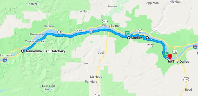
Our time at the hatchery is soon coming to an end. One place we haven’t explored very much is The Dalles (13,000 souls).

dalles-trip-1
The Dalles- Mt. Hood in the Background

This place is of historical significance as it was the location where pioneer emigrants had to build rafts and travel by river in order to continue their journey to the Willamette Valley. Later another choice was offered as a fella by the name of Barlow built a toll road around the south side of Mt. Hood. That meant a choice of rafting the treacherous Columbia River Rapids or paying to continue on dry land. A Pioneer Discovery Center is located just outside of town that tells the story of the pioneers and those who followed.

P1070004
Mosier Totem

Our route to The Dalles took us through the burg of Mosier, then up and over the bluffs that overlook the Columbia Gorge via old Highway 30.

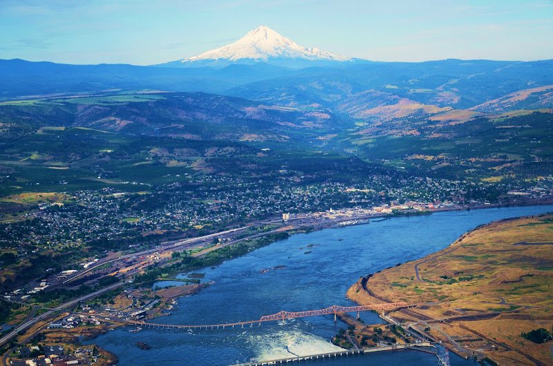
We are glad we chose this 20 or so mile route as the scenery was spectacular. We passed several wineries and farms that are built in the rolling highlands, then stop at the Rowena Crest Overlook.

Views From Rowena Crest Overlook

From the overlook one can see the twisty highway making its way down the bluffs towards the interstate as well as an overview of the Gorge itself. The only downside was there was a heavy haze in the air that smelled like smoke.

P1070012
Old St. Peters Catholic Church

The one place we wanted to visit in The Dalles is the old catholic church. The old church’s steeple stands 176′ high and was considered a navigational landmark by ships captains. However, the original St. Peter’s Church was deemed too small by its congregation, a new church was built and the old church was to be demolished. A handful of town folks caught wind of the church’s impending doom and raised enough money to buy the old gal. So that’s what they did. A preservation society was formed in 1971 which has been dutifully maintaining the church ever since.

Although the church needs a little t.l.c. she is really in pretty good shape. A docent, a non-catholic, told us all about this beautiful lady as well as the trials and tribulations of those who care for her. We are very glad we chose to visit this church.

On another note we were fortunate to visit with some dear friends, meeting them in Troutdale for lunch. As luck would have it Tim and Renee had spent the summer in their newly purchased home in Custer, S.D. and were traveling right by the hatchery on their way to SoCal. A day or two out Tim suffered a detached retina so they hightailed it to the highly recommended Casey Eye Institute in Portland to get Tim’s eye patched up. We met them about a week after the operation and he seems to be doing OK with some vision already restored. As with all old pals who haven’t seen each other for too long a time the conversation started where it left off.  It was sure great visiting with them once again and we are looking forward to our next meet. Via con Dios, our friends.

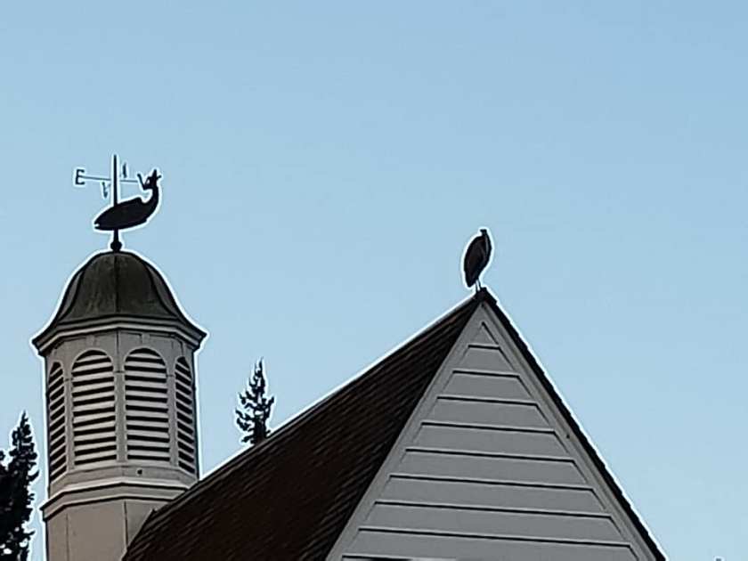
A Merganser and an American Dipper at Work in Tanner Creek

Meanwhile, back at the hatchery:

Today we were refreshing the fish icons stenciled on the asphalt walks. Following the fish takes one to the more interesting parts of the hatchery, mainly Herman the Sturgeon, the upper and lower trout ponds and the visitors center. Jil and I sweep off the old, worn stenciled fish, place the big fish stencil over the old and line it up as good as we can. Then out comes the special line spray paint and viola!, we have a freshly painted fish on the asphalt.

So as to warn folks that they shouldn’t walk on the freshly painted fish we put out small traffic cones adjacent to them. Ya, you guessed it, not more than a minute after the paint and cone goes down, in my presence, two 8-10 year old kids walk right through the fresh paint, nearly tripping over the traffic cone in the process. Too late to stop the kids I was able to reroute Dad. Fifteen minutes later the same two kids and Dad come out of the gift shop and all three of them walk past the cone and trample another freshly painted fish! The sad thing is that not one of them had an electronic device in hand to distract them….. They were just blissfully unaware of their surroundings. Good thing we don’t have any cliffs at the hatchery……..

Thought For The Day is again – Common sense is not a gift, it’s a punishment. Because if you have it you have to deal with all the people who don’t.

Road Trip(s)!

Thursday, October 18, 2018

map to troutdale

So you were thinking that volunteering at the Bonneville Fish hatchery is all work and no play, eh? Not so! We’ve taken several day trips and lucky you, this is the post where I’ll catch you up on the majority of them.

We’ve gone on a few reconnaissance missions in the last week or two. We went back to Trout Lake on a relatively clear day with the desire to see Mt. Adams. No, we didn’t travel any gravel roads this time, we took a more direct route. That recon mission was successful as the big volcanic peak was out in plain view.

P1060977
12,281 Foot Mt. Adams
P1060978
Another View of Mt. Adams

We also took a 90 mile trip in hopes of catching Mt. St. Helens with her pants, er, clouds down. It’s a beautiful drive through the northwest forest, the road initially following the Wind River valley out of Carson, WA.

Unknown

We stopped at the closed for the season (October 1) Paradise Creek Campground operated by the U.S. National Forest Service to stretch our legs and let the mutzos sniff. While it offered no amenities other than vault toilets and a fresh water spigot each site was paved, many large enough for a motorhome and toad or a 5th wheel and tow vehicle. And talk about beautiful- tall old growth cedars, fir, alder and maple make this shady campground drop dead gorgeous.

map to northwoods

We turn left on Curly Creek Road, leaving the Wind River Canyon. Curly Creek road is another good road, a windy mountain road but it’s in good condition. When we arrived at the Mount St. Helens overlook there she was in all her glory.

P1060984
View of Mt. St. Helens Looking Northwest from Curly Creek Road Overlook

P1060986

The weather was almost perfect the exception being some haze. This is our second trip to this viewing area and we’ve been lucky to see the mountain both times. We spend some time drinking in the view before continuing on.

Curly Creek Road tees into NF90 and brings one to make a decision. Turn right and drive into what I perceive as oblivion, not knowing where the heck it goes……. or turn left and head downhill to the establishment of Northwoods. Northwoods consists of a convenience store and a bunch of cabins know as Swift Forest Camp, most lining the beautiful Swift Reservoir.

We stop at the Eagle Cliff Store and purchase a bite to eat. The proprietor states that today is perfect for viewing from the Mt. St. Helens and Spirit Lake overlook from Windy Ridge. Jil and I make a joint command decision- we don’t feel the urge to travel an additional 94 miles round trip up and back on a windy national forest road so we pass. While here we walk the mutzos through the Eagle Cliff campground. Boy, do they love all the smells the forest has to offer!

The lure of the Swift River beckons. We ford the river (just kidding), drive past the ranger station and drive through the cabins toward the Swift Reservoir. Swift Forest Camp is a PacifiCorp campground. It is located on the same spur road that leads to a picnic area and boat launch. This campground was also closed for the season except for a few sites located outside the closed gates. Boy, the second drop dead gorgeous campground that we’ve seen today!

Our fun meter is pegged out so off towards the barn we go. Over mountain, down the valley and through the gorge, over the bridge and into the hatchery we go- just in time to walk the dogs- again!

map to multnomah

On another Columbia Gorge-ous day we chose to go to historic downtown Troutdale (15,000 souls) and have lunch at the General Store. The hot dogs are delicious! Troutdale serves as the western gateway to the Historic Columbia River Highway (completed in 1929), the Columbia River Gorge, and the Mount Hood Scenic Highway. The Columbia and Sandy Rivers are nearby. It would certainly be a shame if one was in the area and didn’t visit Troutdale. More of a shame is not to take the time to drive the Old Historic Columbia River Highway.

Vista House at Crown Point

That’s Vista House……. Way Over There!

The Historic Columbia River Highway was completed around 1929. The west end does not follow the river bottom very closely but it does traverse cliffs and forest glens while passing several beautiful waterfalls. One can’t be in a hurry on this road as it is very narrow (built during the Model T era) with more twists and turns than a woven rope. Vista House on Crown Point was built to take advantage of the beautiful panorama of the Columbia Gorge that this overlook 730′ above the Columbia River offers.

We’ve been itching to visit the ever popular Multnomah Falls. Every time we go by the huge parking lot is full- signs flash “Parking Lot Full”. Hey, this isn’t during the prime summer months for gosh sakes, this is FALL! We took a chance arriving at the falls parking lot before 9 a.m. and found it not full for a change.

Walking towards the falls we notice quite a few hombres dislodging tree logs and rocks from up high on a steep slope. Their work was necessitated by the Eagle Creek Fire- the fire has killed a lot of trees and loosened the soil that used to retain those boulders. P1060960big So the workmen are using safety gear for themselves and lowering logs and boulders to a place where they can safely drop them down to this closed section of the old highway. From there the debris is removed for disposal at a remote site. A several mile section of the old highway will remain closed until the time all the hazardous timber and boulders are removed.

Multnomah Falls is one of the most spectacular falls that we have ever visited. The fall drops twice for a total of some 620′. The lodge and footpaths is listed on the National Register of Historic Places. One can enjoy a great lunch at the lodge, then hike up to the top of the falls if one desires. This fella doesn’t desire, but Jil and I and the mutzos have walked up the trail to that bridge.

P1060964

Jil and Doyle Enjoy Multnomah Falls

So that’s the extent of our day trips up to this point in time. More adventures to come……

Showers, Hatchery Happenin’s and More Info on the 2017 Eagle Creek Fire

BONNEVILLE FISH HATCHERY: WEEK SIX

MONDAY, OCTOBER 15, 2018

P1060976
Sunrise- Host Site #2

The Columbia Gorge definition of rain showers is somewhat akin to my definition of a cloudburst, a deluge if you will. Last Saturday’s morning starts with a steady rain. As the sun comes up rain ends leaving mostly cloudy skies. We are on duty so we spend quite a bit of time doing our morning chores and interacting with visitors. Around 1330 hours we decide to take to mutzos for a walk- just a few big raindrops falling at the time. We get halfway to the garage when the heavens open up with a very intense “shower”. It rained so hard that by the time we scurried the 600 feet back to our RV the roads had puddled and we as well as the dogs were soaked. We tried to open the door to the RV so Jil could go in and grab a couple of towels but the dogs had other ideas. The wedged themselves into the crack of the door and wouldn’t be left outside, even under the awning. So we all piled in soaking wet where the dogs were toweled off and we changed our soaking wet clothes. Some shower!

salmon eggs
Fertilized Chinook Eggs

Salmon that had been sorted out as spawners have been inspected. The females that have ripe eggs have been spawned, the ones that aren’t ripe have been returned to the spawning ponds. Those eggs gathered from the spawners go into a bucket containing water that reminds me of a large popcorn bucket one would buy at a movie theater. Milt from a male is added and presto! The red eggs turn pink, indicating that they have been fertilized. And fertilization is just that fast- instantaneous! A liquid anitmicrobial is added to the bucket to protect the fertilized eggs. The fertilized eggs are transported from the spawning room to the largest building on hatchery grounds, the Egg House.

42503892_10216915263654648_5978101821808312320_n
Rearing Ponds in Foreground, Egg Incubation Room in Background

The eggs are placed in shallow baskets that have a constant flow of water running through them. The eggs are constantly monitored both by machine and by humans to determine their viability. If an egg dies it is removed. Eventually the eggs hatch, the young fish are fed and supported until they are large enough to go outside into the rearing ponds.

racewaysCreston
Fish Guys Working a Rearing Pond Full of Salmon Fingerlings

And there predators await them, mostly birds like the great blue heron, lesser herons, egrets, gulls and occasionally mammals like otters looking for a free dinner. The predators are thwarted by smart Fish Guys who have placed netting over the ponds. An estimated 1.8 million eggs have been harvested to date.

I believe I mentioned that our friends and fellow hosts here at the hatchery were present during the big Eagle Creek wildfire. Here is a link to their blog: https://jimconnietravel.wordpress.com/2017/10/01/fire-fire-and-more-fire/

Here’s a Youtube link to a helicopter flyover of the Eagle Creek Fire dated September 23, 2017- the day I-84 was opened in both directions, two weeks after the fire started……..:

Even though all four of us hosts have worked either in the public sector or worked directly with the public through private enterprise we are still amazed by the lack of common sense by some folks. Case in point- two bus loads of people with learning disabilities pull into the parking lot and unload. The folks on board are having a great time touring the hatchery. Many carry water bottles which the thirsty folks have consumed. Jil spots several of them refilling their water bottles in the Jumping Salmon Fountain located in front of the gift shop. Now this fountain has seen thousands of dirty fingers and a bunch wild critters make contact since we cleaned it last month and God knows what is growing in that clean looking but nasty bacterial soup. Jil stops those unsuspecting folks from filling and probably drinking that unclean liquid and dumps their bottles in the trash. Where are their guardians? Who is getting paid for looking out for those folks, anyway? Raise your hand if you are absent!

Thought For The Day – Common sense is not a gift, it’s a punishment. Because if you have it you have to deal with all the people who don’t.

Where the Heck is Goose Lake?

Week 5: Saturday, October 6, 2018

42537003_10216915264734675_8266205958959529984_n
Great Blue Heron Imitating Salmon Weather Vane

We worked a lot last week, OK? Jim and Connie were busy with personal business part of the week, the weather was pretty good and visitors just kept acomin’. More visitors were drawn in because the gift shop was having their annual weekend sale. More visitors equals more work maintaining the joint, capiche? Not a record setting sales weekend for the gift shop but a strong one.

BFH P. Creek, Trout Lake

As busy as the hatchery was Jil and I snuck away for an adventure. Jil wanted to go to Trout Lake, Washington because the views of Mt. Adams are supposed to be spectacular from that location. I wanted to go to Panther Falls as I hadn’t seen them the first time we went there as I had an achilles tendon that was bothersome. So what do we do? Take a big loop route, first to Panther Falls, then on to Trout Lake in the hopes of a clear view of Mt. Adams.

I planned our route via Google Maps and the whole loop is only 54 miles- piece of cake! So off we go across the Bridge of the Gods for the umpteenth time and drive through Carson WA. We continue on the Wind River Highway then turn onto Panther Creek Road.

42803622_10216962720081029_1681596455069941760_n
Beautiful Fall Colors in Jurassic Park- See the T-Rex Hiding Behind The Tree?

The creek road gives one the feeling that they are on a Jurassic Park jungle ride as the growth of trees and understory plants is amazingly thick. On almost expects to run into a T Rex or maybe a deer even. The road is just wide enough for vehicles to pass one another. Emphasis is on caution as the dense vegetation limits visibility on the curvy road. There is no part of this road that I’d drive faster than 30 miles an hour, with most of it in the 20- 30 mile per hour range.

Sign to Falls Hard to Find, Others are Easy and Very Explicit

As impressive as Panther Falls is the signage is not. The best way to find the falls is to first find a large dirt parking area. Search for a nondescript wooden sign announcing the falls nailed on a tree on the opposite side of the road. Someone has also painted “Panther Falls” with a directional arrow on the road’s pavement but that’s not visible from a vehicle in motion.

P1060956
Panther Falls Trail

The very narrow and steep trail down to the falls requires one’s full attention as to avoid the many root and rock tripping hazards. Once down one finds an observation platform in which to view the impressive 100′ falls- and they are really beautiful.

P1060947
Panther Falls
o
Perspective of the Fall’s Height
P1060952
Panther Creek Just Above the Falls

Off we go up the road where it tees into a gravel forestry road. We leave Jurassic Park and a in a more open forest strewn with volcanic rock outcroppings. We take that road a distance of over 10 miles traveling at no more than 30 miles an hour. The little oncoming traffic there is throws up a lot of dust. Our next stop is Goose Lake, a natural lake that lies in a bowl formed by volcanic activity. The water level in the lake appears to be low. Well, it is the end of the dry season, ya know.

42611641_10216962605198157_4977485479629815808_n-1

42831069_10216962603718120_2910720360364113920_n

Goose Lake

More dusty bouncy gravely road takes us to a spur road. A sign announces that the Natural Bridges are this way. We drive to the parking area expecting to find an informational sign which would tell us how long a hike we’d have to the bridges but no such luck. Not knowing how far the caves are from the parking lot we pass. The next spur road with signage is to the Guler Ice Caves. Not knowing how far we’d have to travel and or hike to the caves we again pass.

P1060957
Trout Lake General Store
P1060958
We Appreciate The Levity!

Eventually we find pavement and continue on the Trout Lake. We looked all over the place and never did see a stinkin’ lake! What’s with the name? Anyhow, Trout Lake (560 souls) isn’t much of a town. We stop at the general store and buy some lunch munchies as we didn’t find a restaurant. Highway 141 parallels the White Salmon River through a lovely farm dotted valley which eventually narrows as it reaches the Columbia Gorge. We head home paralleling the Columbia River, cross it via the Bridge of the Gods and head the four miles west to our home away from home. We throughly enjoyed this outing even though it seemed much longer than what I had calculated as 54 miles round trip. A double check on Google Maps proved me right- 94 miles if its a foot………

BFH- Week 4- Another Long Post!

Saturday, September 29, 2018

I couldn’t figure out why my posts have been so long but I finally had an epiphany. Rather than writing and posting several blogs a week I’ve decided to write only one. And that is why my blabber fingers have been writing such long posts. Duh!

P1060898

The Fall Salmon Run has been very light. Mature fish return to the hatchery anywhere from three to five years from release. Immature salmon known as jacks have returned to the hatchery in almost unprecedented numbers. They are basically yearlings about the size of a trout, that have no business coming home now as they can’t reproduce. The Fish Guys think that early release of fingerlings that was necessitated by the big Eagle Creek Fire may be the cause. Nonetheless, the mature fish are being spawned. The jacks become food for Herman and company.

Preparing to Feed Herman the Sturgeon and Friends- and Herman knows it!

The jacks are laid out on the floor in the walk-in freezer room, and we bag them after they are frozen. We completely filled up one 4’x4’x 3′ tote with 25 bags or approximately 500 jacks just from one harvest! That could be a year’s supply of food for Herman- and there will no doubt be more. To feed Herman the Sturgeon and others in Herman’s pond as well as the sturgeon in the other sturgeon pond the frozen jacks must be prepared. First, a frozen bag of jacks are taken from the walk-in freezer room over to the band saw. Yes, a wood, in this case fish, cutting band saw. The saw is used to cut the jacks into smaller pieces that the smaller fish can handle. Eight to 10 fish are left whole and placed into a bucket. The pieces of fish are evenly divided into two buckets. Now those frozen fish must be thawed in order to be edible and are left overnight at room temperature to thaw. The next day the whole frozen fish have thawed to the point of being slimy and the chunks have turned into a sort of primordial soup. Yum! The whole fish are fed first so that the big fish will eat those and not the smaller pieces meant for the smaller fish, then the chunks/primordial soup is served after about an hour’s wait. One can imagine that serving breakfast to the fishies can get quite messy!

So today we have a predicted rain day. We’ll use today as an example of what’s normal for a rainy day prediction here at the hatchery. Weather guessers say rain for two hours in the morning- prediction= percentage 40% chance. Rain to slacken to occasional showers by afternoon- prediction= 40% chance. Well folks, it rained almost all morning with few breaks. It rained almost all afternoon with just a few more breaks than in the morning. No sun breaks…….. nope, nada, keiner. The rain slackened just enough to let the dogs out to do their then start up once again. Mostly not a hard rain but one that gets everything wet.

Occasionally Mom Nature likes to lull one to sleep with the soft pitter patter of falling rain on the roof. Then the pitter patter stops. Let’s take the dogs out before it starts to rain again. Mom Nature somehow senses our intent and waits until we exit the coach and have walked about a hundred yards. Then BUSSHHH, she dumps a huge bucket of water directly on our unsuspecting bodies- a deluge! How the heck does she know? I did see a pretty sunset way off in the distance about the time the heavens opened. We get the soaking wet mutzos inside and towel them off. Nothing like the smell of wet doggies!

42202083_10216880970797348_6228407735520591872_n

We were in need of a nice day trip. We decided to cross the Bridge of the Gods and head west on Highway 14 towards Camas, WA. We drive by the Bonneville Dam and stop at the day use area provided by the Corps of Engineers. On the premises is the sight of the now defunct Fort Cascades. A series of three forts were built to protect the Cascade Rapids portages. The fort was constructed in 1855 to protect the portage around the final section of the Cascades Rapids. It burned in 1856, was rebuilt and abandoned in 1861. In 1894 the small community site that was built around the fort as well as the fort site were obliterated by the largest flood of the Columbia River in recorded history.

Unknown


Views From North Bonneville, Washington

Continuing on we made a stop at the city of North Bonneville. This place was originally located in the area flooded behind the Bonneville Dam. The town was relocated below the dam and rebuilt by the Army Corps of Engineers. Nearly 600 people live in this master planned community. Homes are built on large lots which are situated around parks and common grounds. It’s a quite lovely place to live. The downside is there is really no downtown shopping area. It does have a civic center complete with social hall, city hall and a post office.

Highway 14 west of North Bonneville takes one through some very thickly forested county, so thick one can’t see the forest for the trees- so to speak. The road winds over hill and dale eventually leveling out on a flood plain. At the west end of that plain, up against a hill is the City of Camas.

Mill workers still without contract    [JUMP]

One could drive right past this town and only see the giant Georgia Pacific paper plant and never notice the quaint, picturesque and historic downtown of Camas (19,300 souls). Camas lies smack dab in between the adjoining cities of Washougal (pop. 15,000) and Vancouver (174,000 souls). Ironically, the city of Vancouver is considered a “suburb of Portland, OR” by Wikipedia. even though a state boundary line and the mighty Columbia River separate the two.

There’s a Bunch of Nuts in Camas!

The historic Old Town Camas is a walkers delight. Not too big, not too small- just right. There’s lots of eye candy i.e. beautiful old style street lamps adorned with flowering plants, and interesting store fronts.

There are lots of signs which are apparently posted by concerned citizens out on the sidewalks with messages that I do not understand with an equal amount that I do.

Since no bridge exists over the Columbia at Camas we continue into Vancouver. An informational sign indicates that its a 30 minute drive to Portland even though it should take 10. Traffic is bumper to bumper for about two miles when we come to the source of the logjam- a minor accident, the vehicles are not blocking the roadway and an officer is on scene taking a report. Once past we accelerate at warp speed, turn onto the southbound I-205 and again onto the eastbound I-84. Our goal is to exit at Troutdale and hit the outlet mall. We buy shoes at a shoe store and some goodies from the Hanes store.

We decide to follow the old Historic Columbia Gorge Highway. It parallels the Sandy River for a ways then heads up to Corbett. We like driving this portion of the highway as it passes through rolling farmland before diving down into the Gorge. Much of the historic highway is closed as the Eagle Fire of 2017 created rock fall and falling tree hazards that haven’t been cleared yet. We head down off of the mesa and into the Gorge and then eastbound on I-84 once again.

We are back at the hatchery safe and sound in our home away from home. More to come……