Week 5: Saturday, October 6, 2018
We worked a lot last week, OK? Jim and Connie were busy with personal business part of the week, the weather was pretty good and visitors just kept acomin’. More visitors were drawn in because the gift shop was having their annual weekend sale. More visitors equals more work maintaining the joint, capiche? Not a record setting sales weekend for the gift shop but a strong one.
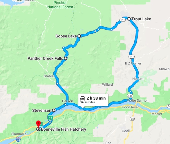
As busy as the hatchery was Jil and I snuck away for an adventure. Jil wanted to go to Trout Lake, Washington because the views of Mt. Adams are supposed to be spectacular from that location. I wanted to go to Panther Falls as I hadn’t seen them the first time we went there as I had an achilles tendon that was bothersome. So what do we do? Take a big loop route, first to Panther Falls, then on to Trout Lake in the hopes of a clear view of Mt. Adams.
I planned our route via Google Maps and the whole loop is only 54 miles- piece of cake! So off we go across the Bridge of the Gods for the umpteenth time and drive through Carson WA. We continue on the Wind River Highway then turn onto Panther Creek Road.

The creek road gives one the feeling that they are on a Jurassic Park jungle ride as the growth of trees and understory plants is amazingly thick. On almost expects to run into a T Rex or maybe a deer even. The road is just wide enough for vehicles to pass one another. Emphasis is on caution as the dense vegetation limits visibility on the curvy road. There is no part of this road that I’d drive faster than 30 miles an hour, with most of it in the 20- 30 mile per hour range.


Sign to Falls Hard to Find, Others are Easy and Very Explicit
As impressive as Panther Falls is the signage is not. The best way to find the falls is to first find a large dirt parking area. Search for a nondescript wooden sign announcing the falls nailed on a tree on the opposite side of the road. Someone has also painted “Panther Falls” with a directional arrow on the road’s pavement but that’s not visible from a vehicle in motion.

The very narrow and steep trail down to the falls requires one’s full attention as to avoid the many root and rock tripping hazards. Once down one finds an observation platform in which to view the impressive 100′ falls- and they are really beautiful.


Off we go up the road where it tees into a gravel forestry road. We leave Jurassic Park and a in a more open forest strewn with volcanic rock outcroppings. We take that road a distance of over 10 miles traveling at no more than 30 miles an hour. The little oncoming traffic there is throws up a lot of dust. Our next stop is Goose Lake, a natural lake that lies in a bowl formed by volcanic activity. The water level in the lake appears to be low. Well, it is the end of the dry season, ya know.


Goose Lake
More dusty bouncy gravely road takes us to a spur road. A sign announces that the Natural Bridges are this way. We drive to the parking area expecting to find an informational sign which would tell us how long a hike we’d have to the bridges but no such luck. Not knowing how far the caves are from the parking lot we pass. The next spur road with signage is to the Guler Ice Caves. Not knowing how far we’d have to travel and or hike to the caves we again pass.


Eventually we find pavement and continue on the Trout Lake. We looked all over the place and never did see a stinkin’ lake! What’s with the name? Anyhow, Trout Lake (560 souls) isn’t much of a town. We stop at the general store and buy some lunch munchies as we didn’t find a restaurant. Highway 141 parallels the White Salmon River through a lovely farm dotted valley which eventually narrows as it reaches the Columbia Gorge. We head home paralleling the Columbia River, cross it via the Bridge of the Gods and head the four miles west to our home away from home. We throughly enjoyed this outing even though it seemed much longer than what I had calculated as 54 miles round trip. A double check on Google Maps proved me right- 94 miles if its a foot………
