Thursday, October 10, 2024
This is a bonafide rant! Before I say anything else I must warn you of the route to Gladstan RV Park. Getting off I-15 and onto surface streets is pretty straight forward. Gladstan Golf Course and its RV park are up in the hills east of downtown Payson (21,101 souls). So following a few surface streets is no biggie. Then we hit the hills. We make a very sharp left onto Goosenest Drive. Goosenest is a narrow country lane splitting several tree orchards before it winds into a large housing tract with 3500-4500 square foot homes.
This sign is supposed to say Olympic Lane so turn right here!
We follow directions and take the first turn out of the round about (yes, a round about). Both of our GPS’s give up the ghost now so we wind up at the clubhouse (not recommended at the parking lot is not big rig friendly but is the only place to turn around). We call and the fella says go back down the hill, turn left at the first street past the LDS temple, then turn left at the street between houses.

The tiny direction sign pointing us towards Gladstan RV Park- sheesh!
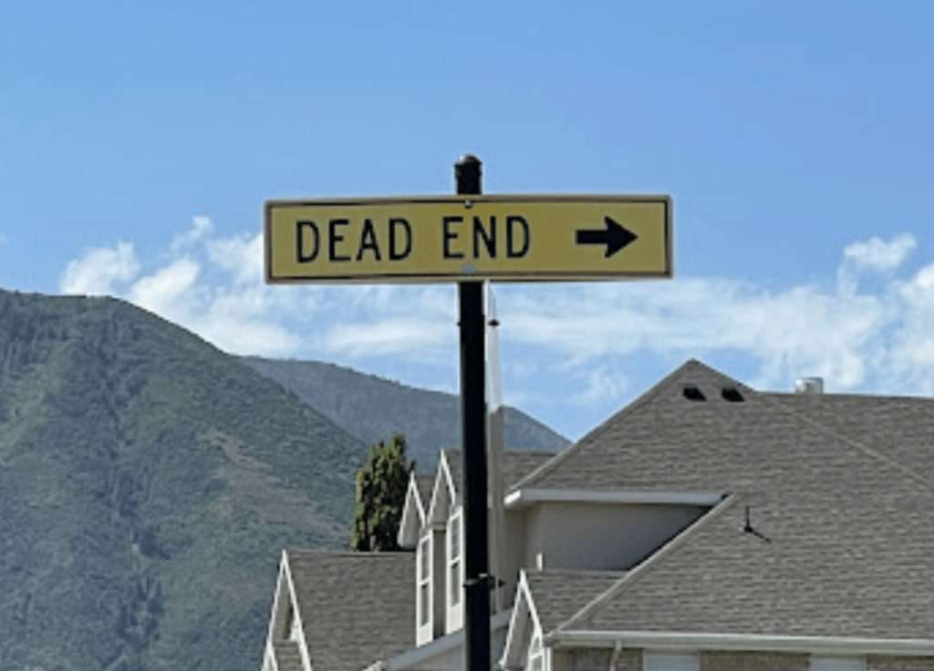
OK, we made it. We were supposed to turn right on Olympic Lane. The street sign post for Olympic Lane does not have that name it has a “Dead End” sign in it’s place. At the driveway into the RV park is a 4″x 6″ sign mounted on the post for Sunbrooke Drive, the entrance to the RV Park. Now how in the heck can you find Olympic Lane since there is not street sign and you are supposed to read the camping sign from across the street while driving an RV. Humph!
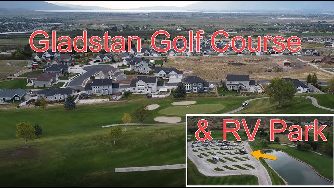

The park was great for the mutzos. Not too many other dogs and lots of grass to walk on as long as they are not on the fairways.

The route we took

The route we should have taken is mostly on Interstate 15 and much less stressful
OK, enough of that. After a pleasant two night stay at the Gladstan RV Park we head back to I-15 heading south to Scipio where we pick up US 50 where we will join US 89. Ok, I’ll tell you right now that the GPS got us again. We should have taken I-15 to exit 95 and taken Utah20 to Panguich but a photo on Google Maps was transposted with the turnoff at Scipio leading us to believe that the Scipio exit to US 50 was the correct exit. I assure you, US50 to US89 is not the best way to travel to Panguich Utah especially when one can’t find US89!
It seems as if we had gone too far east to join US89, the highway we are to travel to Panguich. Due to the road configuration the GPS was correct but I wouldn’t believe it when it told me to go west on I-70 for many miles. So I-70 and US 89 are actually one for several miles bur is only marked as I-70. We jump on I-70 and I tell Jil that this route doesn’t seem right (turns out it is- maybe) so her GPS says get off on Utah Highway 24, so we do. Within ten miles her GPS is giving us weird directions. We relent, the GPS takes takes us back to Utah-24. Hmm. How did we get off of Utah 24?


Town of Koosheram in the Koosharem Valley
So we take this narrow highway south seemingly to nowhere as there are no towns and very few farm houses as we follow a narrow valley south. After quite some time we take a right onto Utah 62 which is even narrower. I keep questioning the GPS directions but abide by them. At this point what choice do I have? The only town, er, village we cross is Koosheram, it’s name originating from the Piute Indians. It’s named for the deep red clover that grows in the lush meadows of the Koosharem Valley. The population of this metropolus is 276 souls………..

Kingston Canyon
We finally come to a T intersection. Jil says we can go either left or right but right gets up back to safety and US 89 so we turn right onto Utah 22 and immediately are met with a “Flooded” warning sign. Cars are coming from that area so we a pretty confident the warning has past its prime. We head down the narrow and scenic Kingston Canyon which opens up before the farming community of Kingston which is even smaller than Koosheram at 136 souls. We reach US89 and turn south.

We travel through Circleville (547 souls) which derives its name from the circular shaped valley that it is in. This place is of great sadness. Back in 1866 a small band of Paiutes were camping in the valley, trying to be friendly with the Mormon pioneers who had settled there. The Mormons were led astray by a letter which said the Indians planned to attack. The Mormons rounded the Paiutes up and as they did a young Piute warrior fired a shot which precipitated the massacred 24 of 27 people. Three children escaped. One died, now one knows what happened to the second, the third boy was captured, sold for a horse and grain, but eventually adopted by the family who purchased him.
We pass a few RV parks before arriving at Panguich (1725 souls). Panguich is the seat of Garfield County. It gets its name from the Paiute, meaning “Big Fish” as there are many nearby lakes which have plentiful rainbow trout.
Well since we are here, why don’t we visit Ruby (Reuben) and Minnie Stretts place- Ruby’s Inn? Lets go!

Rough stories from the settlers years. Grateful for memorial sites to educate us. Hard to believe Butch’s home is still standing; no doubt due to lack of rain. Miss you guys.
LikeLike