B.F.H.- Week Three: Just When You Think It’s Over, It Ain’t

Saturday, September 22, 2018

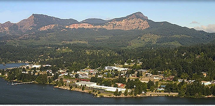
Stevenson Washington (2400 souls) is the Seat of Skamania County. We do most of our grocery shopping there as well as attend Mass on Sundays. Stevenson has a lot more to offer than Cascade Locks and is only 3 miles farther. The local A&J grocery store is pretty well stocked and the town has few nice restaurants, a pharmacy, a hardware store and an auto parts store. Stevenson is also a port of call for the river tour boats which have the appearance of the old Mississippi stern wheelers. At seven miles distance, Stevenson is a lot closer than traveling 20 miles either way to Hood River or the Gresham/Troutdale/Portland area for basic supplies. Besides, the view from The Bridge of the Gods looking up and down river is outstanding!

slide1
Stevenson, WA

We took a trip on the Stevenson side of the Gorge east to White Salmon (2400 souls), again to escape the rain. The rain followed us! WA 14 is also known as the Lewis And Clark Highway as The Corps of Discovery used the Columbia River Gorge to reach the Pacific Ocean in 1805.

BFH to White Salmon

Washington Highway 14 runs between Vancouver, WA and Plymouth to the east. In places it is a hilly, twisty two lane road. As one travels farther east the road flattens out and parallels railroad tracks. I think one of the highlights of this section of road are the tunnels. There are seven in all and we go through six. RV’ers who haven’t traveled the 14 are concerned with low clearances but shouldn’t be. Semi’s go through them all the time. The tunnels are arched so the low point is at the vertical wall which most rig drivers would avoid anyhow. An RV’er is always wise to know exactly how tall their rig is as there are many places around the country that have restricted heights.

Unknown
Six Highway Tunnels Between Stevenson and White Salmon. Rail Tunnel to Its Right

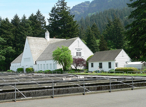
We stopped at the Spring Creek National Fish Hatchery just west of White Salmon. Of course, it’s raining……….. Jil goes into the office and starts chatting with the nice Fish Gal behind the counter……. and its raining……… and I’m outside with our mutzos……… and Jil’s still chatting. I find a post on which to secure the furry ones leashes and head in. Jil’s still yackin’, er, conversing with the Fish Gal so I run into the Little Boys Room. When I come out she is still, ehem……. conversing. I break into the conversation and say “Sweetie, it’s raining outside and the doggies are getting really wet. You know how much you dislike the smell of wet dogs………..” and I walk outside to stay with the furry ones. After what seemed like a week Jil comes out and we walk through the hatchery to the car and climb aboard. Ewwww, it smells like wet dog in here! Sigh……….

Unknown-2

images-2

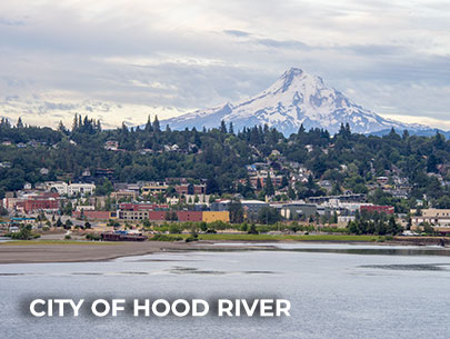
We also did a quick spin around White Salmon enjoying the fantastic views that this cliff-side town has to offer. Couldn’t see as much today for the clouds. The mutzos needed a stretch so we went to the park. On a clear day Mt. Hood can be seen from that location.

Heck, on a clear day Mt. Hood can be seen from almost anywhere in the downtown area as this town sits well over 400 feet above the river- on the edge of a basalt cliff. We believe that the grocery store in town has the most complete inventory of any small town that we’ve visited. It has everything one could possibly need plus a deli and a coffee bar.

On the way back home we stopped at another Federal hatchery- Little White Salmon. It’s located at the confluence of the Little White Salmon River and Drano Lake. This hatchery is much smaller than Spring Creek but it sure is surrounded by a lot more beauty.

There’s been enough rain that the Boss didn’t want to mow for fear of sinking his big commercial mower up to its hubs in mud. Enough rain that the planter boxes didn’t need watering. Enough water to limit the amount of visitors to the hatchery which is unusual as they are accustomed to wet weather. After all, we are in U. of Oregon Duck and Oregon State Beaver country.

images-1

But the some of the ones who did visit ask questions us hosts have heard many times before. What is there to see here? Duuhhh- fish maybe? Where can we see the big sturgeon? Can you see that big 4′ by 8′ map displayed directly behind me? Well, it has a location marked “You are Here”. The map is self explanatory in that just to the left of our location is an area marked “Sturgeon Viewing Center. It’s also emblazoned in big white block letters with a directional arrow just below the map, Sir. Ohhhh.

images

Well, how do I  get there? OK, the map also indicates that if you follow the fish painted on the walk, like the one you are standing on, it will lead you to the Sturgeon Display. Oh…….. So once the salmon are spawned do you release them? No sir, they are euthanized in order to spawn the fish. SHOCK! (grabs chest as if having a heart attack) HOW HORRIBLE! No sir, the fish’s life cycle is over when they spawn in a natural setting. Euthanizing them is a lot more humane than them lying is shallow water slowly dying while a great blue heron is tearing meat from their body. Jeez……..

So this week at the hatchery has been almost like every other in that the rain kinda slows down the progress on the special projects list. We did get a few projects completed which I enumerated in the last post. We’ve mostly just kept the ball rolling in between rainy episodes. I did help our Boss Hugh eliminate a water leak in an unused RV utility pedestal located near our own. Couldn’t fix it with the parts on hand so we plugged the pipe. I also repaired a water leak at our own pedestal. An inline water shut off valve had cracked, no doubt from freeze damage caused last winter, was replaced. Jim and our boss Hugh managed to get the Japanese Maple tree out of its old planter with a fork lift and into the new one that Jim made.

348s
Jumping Salmon Water Display in Front of Gift Shop

More rain in the forecast. We’ll see how much more of the wet stuff we receive compared to the predictions.


B.F.H.- Week Two: We Did NOT Bring the Rain!

Sunday September 16, 2018

Bonneville Map

Well, the weather has changed bringing with it rain, rain and more rain. Weather guessers never get the Cascade Locks area of the Gorge right. If they say a little rain in the morning with a couple of showers in the afternoon they really mean a lot of rain in the morning and constant showers in the afternoon with no sun breaks at all. So it is here. The locals are very happy because they’ve seen no rain all summer. Although the rain seems to follow us wherever we travel, WE DID NOT BRING THE RAIN! Honest…..

Our two weeks have consisted of mostly working days with a couple of days off. The pace isn’t hectic by any means and since rainy days don’t make good exploring days we’d rather stick around the hatchery and help out where we can. Besides our regular duties we done extra. Jim made a larger tree planter box of vertical tongue and groove siding. It looks really nice. The next step is how to remove the tree from the old planter and place it in its new home- hmmmm.

348s

We drained and cleaned the pond with the jumping salmon fountain display that’s out in front of the gift shop to get rid of the algae. The algae is gone! Jil and I headed back the ivy from the curb and cleared it from the trees and ramp of the mechanical room. I must share with you that when we maintained an acre and a half of landscaping we were in a whole lot better physical condition than we are today! Oh, my aching back!

41555328_10216814092405430_1266316342097608704_n
Downtown Hood River Looking Towards White Salmon, WA

The Columbia Gorge contains a lot of microclimates. Bonneville is wetter than across the river at Stevenson. In fact, I believe this section of gorge is more wet than any other. So after a couple of days of unrelenting rainfall we are S#$%@ Full of the wet stuff. Less rain falls the farther east one goes. Last week we had a couple of days off. One of those days we drove to Hood River partly or mostly to get out of the rain for a day- and for the most part we are successful. We got there early and took advantage of the light foot traffic downtown, walking up and down empty sidewalks. Downtown is only a few square blocks. The classic two story brick buildings overlook the marina with the town of White Salmon visible on the Washington side of the Columbia.

The town is built on a hillside so downtown’s streets are pretty steep. We had walked down the block when I noticed that the parked cars had tickets of some kind on their dashboards. Hmmmm, this must be a pay to park zone. I then saw a little nondescript kiosk with an icon I didn’t recognize. THAT must be the pay station. A quarter’s worth of time would be sufficient- and I have no change and neither does Jil. BUT, the pay station takes credit cards, so I slip my card in the slot and try to figure out how to debit a quarter from the card and have it cough up a ticket which I will place on the dash of Mr. Subey.

I see a window with digital readout so I push a button quite a distance below it thinking it’s the cancel button. But its not, it’s ringing up 25 cents at every push. Sheesh I am now thinking that if I push the button enough times it will revert to the 25 cents that I am willing to pay. Nope- it gets stuck on $2.75- the max. So I see another button that is cleverly positioned as to be almost impossible to determine its function, hoping that it cancels this crazy transaction, I push it. NOPE! but I hear some whirring from inside the machine and a ticket spits out. Crap, we’re only gonna be here another 15 minutes and I bought an all day ticket- with no one around to give it to when we leave.

Cruise Paddlewheeler, Hood River Bridge, Popular Brewery

We head past the airport and into farm and orchard country traveling now on the popular Fruit Loop. A lot of folks who grow apples, pears, cherries and other tree crops as well as berries and U-pick flowers have stands on or near this loop route. Nearby are lavender farms and alpaca farms. It’s very popular during high fruit season. Cherry season is over and apples and pears are still hanging on the trees. Odell sports a population of 2500 souls but one would play hell trying to find them. Downtown only has a couple of store fronts but nearby are a couple of large fruit transfer facilities.

We like to stop at the Apple Valley Store located in a holler near the town of Odell. They specialize in fruit and other varieties of preserves, fresh or ready to bake pies, ice cream and Jil’s favorite, the Pumpkin Shake. We leave armed with a bag of preserves, a piece of loganberry pie and, of course, Jil’s Pumpkin Shake. Another “must stop” for us is the Gorge White House. This historic home sits on a working apple and pear orchard. It also has a huge u-pick flower garden aaaannnd a take out stand with the best hot dogs this side of who knows where…….. and the whole kit and caboodle is closed. Drats!

images-3
Hood River Valley With Mt. Hood

Our last stop is Toll Bridge County Park up near Parkville. The drive to the park offers outstanding views of Mount Hood and despite of the rain the mountain is showing itself. The park offers a really nice day use area right along side the Hood River. A very nice RV park is located on the other side of the entrance from the day area. But the RV park is closed as the sewer system is being repaired. The campground host said that we could walk through but we graciously decline.

BFH to Fruit Loop
The “Fruit Loop” Begins and Ends in Hood River

We head back down to Hood River via Highway 35. We might take 35 around Mt. Hood to Highway 26 to Highway 97 when we head towards the barn. It’s a beautiful drive….. But for now we catch I-84 and drive back towards the hatchery………. in the rain……… sigh……


Our First Week At Bonneville

Sunday, September 9, 2018

Bonneville Map
Troutdale, OR 24 Miles to Left, Cascade Locks, OR 4 Miles to Right Via Interstate 84

Our volunteer job at Bonneville Fish Hatchery started on September 1st, the beginning of the very busy Labor Day weekend. The beautiful grounds includes a picnic area, interesting displays, the ever popular sturgeon pond, Herman The Sturgeon’s Pond, two trout ponds one of which displays rainbow trout weighing over 10 pounds. The hatchery rears over 10,000,000 chinook and coho salmon annually. Access to the hatchery is easy on/ easy off I-84 and people take advantage to use the hatchery and adjacent Bonneville Dam Visitors Center as a glorified rest stop. The hatchery can have more than a million annual visitors that includes bus loads of tourists and school students.

BFH copy
Egg Rearing Building on Left, Groundskeeper Office on Right

Ironically, on this very busy three, maybe four day weekend there is only one employee on duty with one in the back up seat, just like every other weekend.. Aaannnd, that employee is working salmon, i.e. feeding fingerlings in the rearing ponds and removing those fish which have expired. They also monitor the water flow through the hatchery thus keeping it a constant volume. They do not interact much or at all with visitors and do not help maintain the grounds unless they are assigned to by the boss or at the request of a host. A Fish Gal, Ann, is occasionally assigned to help our landscape/caretaker boss Hugh. It’s obvious she likes gardening as she does a great job.

20161015_094453
Jil and a Returning Salmon

So that leaves the volunteers. Two teams of volunteers, Jim with Connie and Jil with myself arrived in the late morning on the First, the previous hosts having left. Fish Guy Patrick lets us into the office to pick up our keys to the hatchery and our host books. The host books have a work log and a plethora of information within, including the all-important emergency numbers and procedures. As we watch the hordes of visitors walking the grounds we hurriedly set up our campsites to be functional so that we could go right to work. We’ll finish setting up for a two month stay a little later.

P1030395
Salmon Trying To Swim Upstream…. But Are Blocked From Doing So.

Our daily sometimes mundane but necessary chores include policing the grounds for wayward paper products, i.e. trash and the ever present cigarette butts in the parking area, dumping trash cans, mowing lawns, caring for flowering plants, watering planters, maintaining brochure stations, and interacting with visitors. We also feed the sturgeon a diet of whole (for Herman) and cut up jack salmon once a week, blow leaves from paths and walks, clean decorative pools, jeez, name it and we do it. We just can’t operate heavy equipment with a State Of Oregon Operators Certificate.

14448979_10210210743645838_4412163729280763609_n
Nose To Nose With The Ten Foot Long Herman The Sturgeon

We also help with the not so mundane. Sometimes there’s a big project limbing trees where we can assist. Sometimes like now a Japanese Maple has outgrown it’s planter so Jim was asked to build a larger one. Twice a year- once in the spring and once in the fall salmon return to the hatchery, a.ka. the Spring and Fall Runs, from their time in the ocean. A small percentage of the returning fish are natives, not hatchery raised so they a separated and returned to the Columbia River. A percentage of the returning fish become the spawning fish, the rest are purchased by a buyer.

The Fish Guys and Gals sometimes need some help separating the incoming salmon, also with spawning, i.e. removing the eggs from the ripe females and fertilizing those eggs with milt from male fish. Help is sometimes required to clean and polish Herman The Sturgeons big picture window- inside and out. The water level in the pond is lowered and four or five folks jump in clad in waders and armed with special non-scratch cleaning pads to remove the built up algae. Sometimes the plexiglass window is polished inside and out with the aid of a polishing machine and a fine cut polish, then wiped clean with rags.

00003587472364
Eagle Creek Fire- Photo Taken From Eagle Creek Hatchery

The most significant event of 2017 was the Eagle Creek Wildland Fire. The fire was started by a kid that was launching fireworks off a rock outcropping up on a trail near Eagle Creek on September 2, 2017. He saw a small fire start from the location where he had thrown fireworks but didn’t report it. The fire grew to over 48,000 acres the first couple of days seemed manageable until rapidly spread by strong east winds. The fire even spotted across the gorge to Archer Mountain in Washington State. The visitors center in Multnomah Falls was threatened but fireman did a great job of saving it. That’s a distance of 10 miles from the seat of the fire and that’s about as far as the fire traveled to the west. Part of the town of Cascade Locks was under mandatory evacuation orders.

Early on, Jim contacted me, explained the fire situation, added that a fire captain he had spoken to felt that there was no need to evacuate, and asked this retired fireman his opinion. I explained that if I were me I’d make my camp and rolling stock ready to roll within a half hour all the while vigilantly monitoring the fire situation via news media, updates from first responders but most of all keeping a wary eye on the fire activity. The next thing I heard from Jim is that a half hour after my reply the wind came up, the fire blew up and Jim and Connie were ordered to evacuate! He said that burning embers were falling on the hatchery grounds. Some of the embers were actually small tree branches………

The entire Bonneville Hatchery, volunteers and Fish Guys alike as well as the volunteers at the nearby Bonneville Dam were evacuated to the Skamania Fairgrounds in Stevenson WA. Only skeleton crews were permitted to work at the hatchery in order to try and save the historically significant buildings and to save the hatchery fish. Most of the hatchery fish were moved or released. Interstate 84 was closed, so the only way to the hatchery was over the dam which a requires special permit and clearance from the Feds. The Interstate finally reopened approximately three weeks later after identified hazards such as fallen/teetering rock and 2400 “widow maker” trees were removed. FYI- the kid that started the fire is a minor, was convicted of starting the fire, is accountable for the cost of fighting that fire- to the tune of $11,000,000 smackers! Do ya think that the kid is going to be able to pay that much money back??????

Anyhow, we look forward to catching up with Jim and Connie, even our boss Hugh. We hadn’t seen them for two years. We survived Labor Day Weekend once again and look forward to special projects and even mundane chores.

Our location here at Bonneville Fish Hatchery is Site 2. Drop in and say howdy!

P1060891
Site Number 2 with our Allegro- Big Red, Little Subey the Subaru, and Senior Toro, Our Work Vehicle in the Foreground

P1060900

Two Days To Bonneville- Day Two

Saturday, September 1, 2018

Wildhorse to Bonneville

Warning: this is a long post. Heck, it took me seven days to write it! Feel free to digest it over several days………..

Wildhorse Casino to Bonneville Fish Hatchery

The Wildhorse Casino Resort RV Park, Mission OR is somewhat of a disappointment. The sites are relatively narrow, the grass between parking pads is browned out at about 25 percent of the sites. Some site pads are asphalt and some are gravel. No shade to be had except around the perimeter of the park. Howsomeever, the perimeter, the part that the general public sees is well watered and landscaped. The RV park does have a dedicated swimming pool. Aaannnd, the price is really steep for those who don’t have a casino club card. I don’t have one of those so our rate was a whopping $76 including tax for a one night stay. $35 or $40 would be more appropriate. Native Americans 1, White Eyes 0.

Travel today will be pleasant as our route is Interstate 84 all the way to Bonneville Fish Hatchery. Breaking camp is easy- we are only using the power cord. The dogs have been walked, everything is stowed inside, slides in, jacks up, we are ready to roll.

20180901_072648

This portion of Oregon is composed of rolling hills, dry rolling hills that remind us of Washington’s Palouse. Wheat and bean country. It can get pretty warm out here. The town of Pendleton (15,000 townsfolk + 1600 correctional inmates) is known for its Pendleton Woolen Mills and the Pendleton Roundup sits down in a holler to our north. Located just east of I-84 is the city of Hermiston (17,000 souls), the largest city in eastern Oregon. It has become a logistics hub due to its proximity to I-84 and I-86. If one were to pass Hermiston heading north on I-86  one would drive right through the Tri-Cities of Kennewick, Pasco, Richland and West Richland, Washington.

I count four cities in the Tri-Cities. Why not Quad Cities? Tri-Cities (283,000 souls) is a large metropolitan area located at the confluence of the Snake, Columbia, and Yakima Rivers. Prior to the end of the Cold War the economy was based on the manufacture of nuclear weapons at the Hanford Site. Locals got jittery when the Cold War ended fearing the Tri-Cities would quickly become a ghost town. They should have feared not as the facility’s purpose was switched from the creation of nuclear weapons to the effective sealing and disposal of radioactive waste. During the 1990’s several major corporations entered the Tri-Cities which helped diversify the economy. Despite the economic recession the Tri-Cities continued to maintain steady growth.

20180901_081311
Our First Look At The Mighty Columbia River

Our first stop is at Boardman, OR. The town has a population of 3200, 3100 of which were  in hiding when we arrived. It is named after Samuel Boardman who homesteaded there in 1903. He went on to become the first superintendent of the Oregon State Parks System. The town lies on the southern bank of the Columbia River. Oregon’s second largest port, the Port of Morrow is adjacent to Boardman. We like to stop there because it offers a large, well maintained marina, RV park and day use area right on the Columbia. It’s a beautiful, quiet morning at a great place to stretch and walk the mutzos.

We fuel Big Red and head off westbound on I-84. The fuel gauge continues to read incorrectly but now I feel that it reads about 15% or approximately 16 gallons less than is indicated. Everything is going along just swimmingly until……….. the BIG WIND comes up. We had wind yesterday but not BIG WIND. The wind is blowing over the port rail and is so strong that it feels like I’m at the helm of a sailboat thats heeling– when the wind pushes the sailboat causing it to lean over the water. The  obvious course of action is to slow down. That helps a lot but I still have to fight the strong gusts.

The eastern end of the Columbia Gorge is much dryer and the walls forming the gorge are not as spectacular as say, from The Dalles to its mouth near Troutdale. The basalt rock walls grow higher and steeper as the gorge narrows. For the most part the walls on the southern, or Oregon side are much more vertical and closer to the river than those across the river in Washington. Most of the settlements are either located at the confluence of a smaller river and the Columbia or a road coming from the south. Not many bridges cross the Columbia. Due to the more gentle slope on the northern bank more settlements exist in Washington State.

We pass a few small settlements. Arlington lies at the intersection of I-85 and Oregon 19. Le Page Park, a Corp of Engineers administered facility, is at the confluence of the John Day River and the Columbia. To the west is Rufus (pop. 249) where the average income is below the poverty line.

700px-SamHillMemorialBridge
Sam Hill Bridge With Biggs Junction Is On The Far Right

Biggs Junction consists of a fueling station and a restaurant. Biggs (22 souls) would not exist today if it weren’t for the junction of Interstate 84 and US Highway 97 which crosses the Columbia via the Sam Hill Memorial Bridge. In the days of the Oregon Trail Biggs is near the location where the pioneers would first see the Columbia River. Across the river is the Maryhill Museum of Art (http://www.maryhillmuseum.org) which has quite a history and is definitely out of place here in the middle of nowhere.

40529974_10216729761817218_5128421320584855552_n
A “Tiny House” Passes Us. Mt. Hood in the Background as We Approach The Dalles.

Twenty miles to the west and reached by traveling past the base of high, nearly vertical cliffs is The Dalles. Pronunciation is unlike Dalles, TX. It is pronounced The Dals. The wind hasn’t subsided and the steep cliffs which are in close proximity seem to enhance its intensity. Hang on there cowboy! The entire Columbia Gorge is Lewis and Clark country.

adalles7
The Dalles, Oregon

The Dalles (pop. 13,300) is the largest city along the Columbia outside of the Portland Metro area and is another place of historical significance. It was a major Native American Trading Center for at least 10,000 years. Lewis and Clark camped here in 1805 and fur traders plied their trade here. The Dalles was also the largest and longest of the four great portages where fur trading boats had to unload and transship their cargoes. The Dalles Dam submerged the Long Narrows and Celilo Falls. Another bridge across the Columbia exists here.

We pass Mosier (433 souls) as the Gorge widens some. When the Columbia River Highway was built in 1921, it was necessary to build a pair of tunnels through a high rock point. These tunnels and nearby cliffs were troublesome as numerous rockfalls and accidents happened all to frequently. A new road was completed in 1954 near water level and the tunnels were abandoned.

Mosier Tunnel, Rock Inscribed by Snowbound Who Took Shelter in the 

Tunnel for Eight Days (1921), Historic Columbian Highway Trail

 They were soon filled with rock rubble and forgotten. The west portal was completely buried in fallen rock and trees were growing out of the roadway. In 1995 work was begun to reopen the tunnels for tourist use. Roads were rebuilt and rubble removed. In 2000, the old highway reopened as the Historic Columbia River Highway State Trail. This portion of the trail runs 14 miles  round trip from Hood River to the Mosier Twin Tunnels.

city_of_hood_river

Heading west there is a noticeable change in scenery. A rapid transition from gold hills to green cliffs occurs, an indication that this portion of the Gorge receives a lot more moisture. The next town we come to is located at the confluence of the Columbia and the Hood River, the City of Hood River . This picturesque city of 7600 souls lies on a hillside overlooking the Columbia. The steel Bridge of the Gods connects the city with White Salmon, Washington. South of town is the Hood River Valley which is famous for its production of apples, pears and cherries. The valley is also home to the infamous “Fruit Loop”, a route that takes one to various growers, businesses and fruit stands around the valley. It’s quite fun to visit when all of the stands are open for business. A must see is the Western Aeroplane & Automotive Museum (Western Antique Aeroplane & Automobile Museum) which has a very large collection of antique planes and autos- all of which are in operating condition and all are still flown or driven as the case may be.

The last town on our sojourn and the one closest to our destination is Cascade Locks (1400 souls). The town took its name from a set of locks built to improve navigation past the Cascade Rapids. The locks were completed in 1896. The locks were subsequently partially submerged in 1938, replaced by the Bonneville Lock and Dam.

No land was lost from the expansion of Bonneville Lake behind the dam some 4 miles downstream from the city. The Bridge of the Gods (Bridge of the Gods) is located here and is the only bridge crossing the Columbia between Portland and Hood River, a distance of 62 miles. Cascade Locks is frequented by hikers along the Pacific Crest Trail in order to cross the Columbia. It is the lowest in elevation and the largest city on the Pacific Crest Trail.

P1060893
Home Sweet Home

Okie Dokes: Four miles west of Cascade Locks is our destination. We pass closely by Bonneville Lake, then the Dam. We make the turn off down to the dam access road. Instead of turning right at the fork we turn left, drive through the hatchery parking lot, past the salmon rearing ponds and the visitors center. Near the railroad trestle we turn right down our long gravel driveway, get the coach turned around so that our door faces Tanner Creek and the grassy area in between and ptssssh, set the air brake, level the rig with the hydraulic jacks, extend the slide rooms, hook up the utilities. We are glad that drive is over. Heavy winds made us weary even though we traveled less than 200 miles.

We settle in for two months.

The Two Days To Bonneville- Day One

Sunday, September 2, 2018

McCall to Wildhorse

We are off on Friday August 31. Our commitment at the Bonneville Fish Hatchery begins on September 1st. We don’t know when the hosts at the hatchery are leaving specifically so we assume that they will have departed when we arrive around noon on Saturday. That gives us a day and a half to reach our destination.

The distance from McCall, ID to the Bonneville Fish Hatchery is 422 miles, too far to drive the big rig in one day especially since many of those miles are slower going mountain driving. It doesn’t take long to get the Allegro RED packed up, jacks up and ready to roll. A lot of the preparation is done the night before. We are fortunate that we have room to hitch up our towed vehicle the night before travel. Nonessential utilities are also disconnected and stowed the night before departure.

We’re up bright and early but the sun is not. McCall is on the western edge of the Mountain Time Zone so the sun seems to come up a little late. Only having to pick up and stow the power cord and walk the dogs, we are off by 0730 Mountain Time.

40504542_10216721370847449_8616917182871240704_n
Open Range on Highway 95

We head back the way we came-  head northwest on highway 55 out of town to New Meadows, south on highway 95 down the Weiser River canyon, across rolling farmland passing the towns of Council, Cambridge and Weiser. Cross the Snake River and turn right on highway 201, head north on I-84. Once past Baker City we are in virgin territory- at least for this trip. Been here, done that. The countryside is rolling farmland, mountains in the background for a long ways. We reach LaGrande and head towards those mountains. Within minutes Big RED takes us up a canyon and into the trees.

40463220_10216721370487440_5604447934868357120_n 2
The Rest Of The Gang On The Other Side Of The Road

I don’t think I’ve mention the historical significance of this route. Even today the interstate follows the path taken by the pioneers:

The original fur trader trails could only be accessed by foot or on horseback. But in the 1830’s the first wagon train was organized and headed west from Missouri with the destination being the Willamette Valley of Oregon. A lot of improvements had to be made to the trails to accommodate their wagons so it was slow going. Eventually a trail suited for wagons was established that made its way from Missouri through parts of Iowa, Nebraska, Wyoming, Utah and eventually into Oregon. Various trails spurred off the Oregon Trail to other parts of the West. As many as 400,000 people went West by wagon train. The Transcontinental Railway was completed in 1869. Making the trip west essentially become quicker and cheaper by rail than by wagon train so the use of the trail dwindled. Many of the nearby places are mentioned in the history books- Fort Hall ID, Baker City OR, LaGrande OR, Immigrant Springs OR……….

Once across the Snake River ford near Old Fort Boise the weary travelers traveled across what would become the state of Oregon. The trail then went to the Malheur River and then past Farewell Bend on the Snake River, up the Burnt River canyon and northwest to the Grande Ronde Valley near present-day La Grande before coming to the Blue Mountains. In 1843 settlers cut a wagon road over these mountains making them passable for the first time to wagons. The trail went to the Whitman Mission near Fort Nez Perces in Washington until 1847 when the Whitmans were killed by Native Americans. At Fort Nez Perce some built rafts or hired boats and started down the Columbia; others continued west in their wagons until they reached The Dalles. After 1847 the trail bypassed the closed mission and headed almost due west to present day Pendleton, Oregon, crossing the Umatilla River, John Day River, and Deschutes River before arriving at The Dalles. Interstate 84 in Oregon roughly follows the original Oregon Trail from Idaho to The Dalles.

Arriving at the Columbia at The Dalles and stopped by the Cascade Mountains and Mount Hood, some gave up their wagons or disassembled them and put them on boats or rafts for a trip down the Columbia River. Once they transited the Cascade’s Columbia River Gorge with its multiple rapids and treacherous winds they would have to make the 1.6-mile (2.6 km) portage around the Cascade Rapids before coming out near the Willamette River where Oregon City was located. The pioneer’s livestock could be driven around Mount Hood on the narrow, crooked and rough Lolo Pass.

Several Oregon Trail branches and route variations led to the Willamette Valley. The most popular was the Barlow Road, which was carved though the forest around Mount Hood from The Dalles in 1846 as a toll road at $5 per wagon and 10 cents per head of livestock. It was rough and steep with poor grass but still cheaper and safer than floating goods, wagons and family down the dangerous Columbia River.

In Central Oregon, there was the Santiam Wagon Road (established 1861), which roughly parallels Oregon Highway 20 to the Willamette Valley. The Applegate Trail (established 1846), cutting off the California Trail from the Humboldt River in Nevada, crossed part of California before cutting north to the south end of the Willamette Valley. U.S. Route 99 and Interstate 5 through Oregon roughly follow the original Applegate Trail.

Approaching the Blue Mountains near LaGrande, OR

So our route today includes the passing of historically significant Farewell Bend, Baker City, LaGrande, Burnt River Canyon, Emigrant Springs located at the summit of the Blue Mountains, , cross the Umatilla River, and stop for the night at the Wildhorse Casino Resort and RV Park in Mission.

Wildhorse Casino And Resort RV Park

The wind was blowing hard enough to move the RV around, sometimes a lot! Hope tomorrow’s travel isn’t as windy……..

A Pleasant Five Days In McCall, ID

Thursday, August 30, 2018

McCall Map

McCall (3200 souls) lies at nearly a mile above sea level. It’s a great little scenic town to visit. The setting: downtown is right on the shore of Payette Lake, in the pines and only 100 miles from Boise. Activities this time of year include all types of water sports, fishing either in the lake or the Payette River, hiking, biking, well you name it. Winter sports are also very popular. Downhill skiing on Brundage Mountain, ice skating on nearby Payette Lake and an annual winter festival draws the flatlands by the thousands. On the eastern shore of Payette Lake is Ponderosa State Park, one of the nicest state parks we have visited.

images-5

The only problem is getting from point A to point B when the town swells to 3 to 6 times its year round population. The speed limit through town on the two land main drag US 55 is a proper 25 mph. The problem comes when one wants to cross the main highway when traffic in both directions is traveling almost bumper to bumper. It’s really difficult to either turn left onto the main street or cross it. But I guess that is the price one pays for visiting a little town in the height of tourist season………..


Nearby is another great ski resort, that of Tamarack. Tamarack is a master planned community that includes multiple ski lifts, a class hotel, a world class golf course, single family homes as well as condominiums and townhouses all built on the side of a mountain. Unfortunately the developer, a foreign born person decided to stiff his creditors and blew town leaving the whole community in a lurch.


The building of new condos and townhouses stopped with the buildings not half completed, the ski lifts stopped running and the golf course was allowed to return to nature. On top of that the economy took a dump and many of the residential units fell into bankruptcy. Many of the ski lifts were removed by creditors.


On the upside the remaining landowners have devoted themselves to bringing the community back. They purchased one lift and had it operating last year. The hotel is open, but amenities are limited. There are plans to revitalize the golf course some day but that will take years.


The McCall RV Resort is such a pleasant place to stay. The setting is on the east bank of the Payette River and in pines. The staff is very friendly and the workampers are always pleasant. The sites are relatively spacious with mowed lawns between all but the newer sites that are located most near the Payette  River. About half of the sights are pull through. Of those there are some that actually have a common square between them, each site forming one side of the square with grass and trees between them. These are ideal sites for family and a gathering of friends. Also in the park is a nice large lodge and indoor swimming pool. Free popcorn is alway provided.


A bonus is the wildlife. Every time we visit we see red foxes, but not this time. No one has seen a one of them this year. They used to bravely wander right through the park. Bow hunting season starts this weekend and the deer have come into town. Momma deer and her half grown fawns are taking advantage of the free food here- the landscape plants and trees leaves.


Young Buck @McCall RV Resort; Beaver Dam @ Sumpter Dredge

We went over to Jil’s brother Rob and his wife Kathy’s house, a place new to us. They bought a really nice place about a mile outside of town. It sits on an acre with national forest located behind. Jil’s sister Kim and her hubby Dave came down from Whitefish for a sibling reunion. We all did a lot of catching up, and had a great meal provided by Rob and Kathy.

We spent the next few days visiting with Rob and Kathy and just snooping around this wonderful place. Between McCall and Donnelly to the south is grazing land. A lot of cattle are raised here. The contrast of the wheat colored  grazing land and the green covered mountains in the background is beautiful. The route to Tamarack is travel south from McCall to Donnelly and hook a right, cross over Cascade Lake, drive past 4 Idaho State Park campgrounds and viola, Tamarack!

Payette Lake reminds me of Lake Tahoe. It lies in an Alpine setting with lots of ponderosa pines growing along the lakeshore all the way up to the peaks of the surrounding mountains. Private homes lie on its shores as well as a state park……. and of course the town of McCall.

Not everything goes well when traveling. Here are a couple of examples:


We are preparing to leave on Friday, August 30. We have a two month volunteer commitment at the Bonneville Fish Hatchery beginning on September 1st. Our plan is to travel to Pendleton Oregon, spend the night at the Wildhorse Casino RV Park, then travel in to the hatchery arriving in the early afternoon on Saturday September 1.

We’ll see you there!