Sunday October 28, 2018
Bonneville Fish Hatchery to Bend, OR
Just a note to my readers: The observant reader of this post says “what the heck, that date can’t be right! Well, It is, sorta. That’s the date I started writing this post. Today’s Date is November 25, 2018. We have since arrived at our home, done a lot of work around the house in preparation for winter and the coming Christmas Holiday Season. Yes, time got away from me as three other holidays have past: Halloween, Veterans Day and Thanksgiving. I have one more post to publish, that of the last leg of our trip home. Be patient…………

Should I have said “Where to Go?…… Normally we try to vary our routes. Well we kind of snookered ourselves this time. The best routes towards home involved travel on Interstate 5 passing through the Oregon’s Willamette Valley or US Highway 97 traversing Oregon’s high desert county east of the Cascades. We’ve already traveled Oregon’s Interstate 5 corridor in the beginning of this trip. We also visited Bend’s high desert area on our way to Idaho. The weather has turned more like the Fall we know here in the Pacific Northwest, that being wet. So what to do?
We flipped a coin, heads I-5 and tails US97. It’s heads. We disregard the coin flip and head towards the dryer high desert area of Bend, one of our favorite stops in the State of Oregon. After picking up and packing up on Friday we stop at Jim and Connie’s RV to say goodby. It’s been another good time volunteering with these good friends.

The route to Bend has us we travel east on I-84 to Hood River, south on Oregon 35 which takes us through the Fruit Loop of Hood River and onto the east and south flank of the mighty Mt. Hood. As we climb in elevation the forest gets more dense and so does the low cloud cover- yikes! Although a little foggy in places its not too bad. Everything is soaking wet from the overnight rains which continues into this morning. After about an hour we turn south onto US 26 and head towards Warm Springs. There are no towns between the Hood River Valley and Warm Springs.
Warm Springs Reservation (2400 souls) is governed by a confederation of Paiute, Wasco and Warm Springs tribes. Here is a little history for ya- https://warmsprings-nsn.gov/history/. The region is very dry compared to the Columbia Gorge. However, the Deschutes River runs right through town. Tourism is important so being good tourists we stop at the casino. No, not to gamble but to let the dogs stretch.


Near Warm Springs we pass the turnoff to Ka-Nee-Ta Resort. I later learn that the resort closed before our arrival. Apparently the resort had been losing money for some time. That has to be a sad occurrence for this small Native American community.
We park as far away in the most distant parking area, right on the edge of the pavement. Dogs leashed, they are the first out but refuse to move as soon as paws hit dirt. They look up at us with that “what the heck did you just do to us” look. We look at the ground and they are standing in the sticker patch from hell! We move them out as best as we can, then provide some sticker removal for their paws. Poor mutzos! We spend quite a bit of time picking stickers from 8 paws. We walk around the perimeter of the parking lot looking for sticker-less ground with no success so I move the rig to a safer boarding area. Everyone jumps aboard and off we go.
Highway 26 follows the Dechutes River Canyon for several miles, then climbs up it’s shoulder to the high desert plain. The tail end of the cold front is kicking up quite a bit of wind. The rig gets a little squirrely when it’s hit by big gusts, but remains manageable. A little farther south is the city of Madras (6000 souls), the seat of Jefferson County.

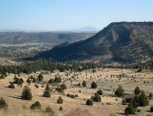
Crooked River Gorge- 400′ deep!
We join US 97 here and continue south towards Redmond (30,000 souls). About 8 miles north of town we stop at the Peter Skene Ogden State Park to view the vertical walls of the Crooked River Gorge. Redmond has grown so much the last decade that Highway 97 no longer follows the most traditional route through most town, Main Street, but skirts downtown entirely.
Another 20 miles south on US97 and we pull into the Crown Villa RV Resort for the second time in three months. Every time we’ve stayed at Crown Villa the place was packed with higher end Class A motorhomes and nice 5th wheel or travel trailers. This trip around Class A’s are in the minority and the place is packed with less expensive travel trailers and a smattering of 5th wheels. The clientele has also changed- a lot more working age folks, some with families and not so many retirees. In fact it looks like a bunch of folks who found work in Bend have brought their home on wheels and their families from who knows where to work here. That’s a good thing!

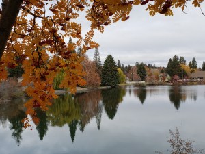
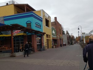
The weather improved, the sun came out for a while, so we saddle up and head to downtown Bend and the Drake Park area. Downtown Bend is turn of last century two story predominantly brick buildings. It’s a thriving little downtown.


Adjacent to it is Drake Park, a large manicured grass park that lies along the Deschutes River. Walking through the park we are delighted to find numerous youngsters and their parents playing in the deep leaf litter. The Deschutes River is dammed just down river, we cross the small lake to the residential side of the river.
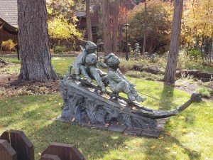

Beautiful Home, Garden Art, Halloween Decor
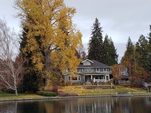
The homes that lie along the river are just incredible. Those fortunate enough have their manicured back yards end right on the lake. We walk through this great neighborhood, across the vehicle bridge, around through a portion of downtown and back to the car. This is one of our favorite activities here in Bend.
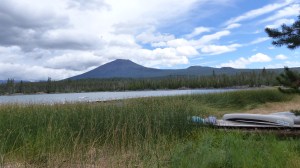
We hadn’t been up on the Cascade Lakes Highway for a while so let’s go! We head up towards Mt. Bachelor with the intent of driving the highway past some very beautiful lakes such as the one below.
Instead we get up to the Mt. Bachelor Village and are greeted by rain turning that is quickly turning to snow. Alrighty then, maybe next time!

MThought For The Day – Mr. Rogers did not adequately prepare me for the people in my neighborhood.

Mike, That house you took a picture of on the Dechutes river. Is my Dads old house, I sent the picture
to my Dad and siblings. They could not believe, That out of all the houses along that river you chose
that one! The people that bought it, loved everything about it. They did not want to change anything.
I am sorry to hear about Ka-nee-ta resort, As we used to go there for a weekend getaway. Beautiful
rooms. Get posts Thank You
Chris
LikeLike