Monday, August 20,2018

Location- Crown Villa RV Resort, Bend, Oregon

Another smoky morning in Silverton. More smoky than yesterday. The rising sun is reddish orange. What’s new? We’ve been in nearly constant smoke beginning last month in Reno and every day on this trip thus far.
We packed up, picked up and were on the road by 0830 hours. For you non- RVer’s packing up is self-explanatory. Ya don’t want stuff flying all over the place while traveling in your home on wheels. Picking up means disconnecting and storing all umbilical cords and hoses. You know, the power cord that supplies electricity to the RV, the water hose, the TV cable and the sewer hose. All these things have a specific place in their respective storage bays. Once picked up and packed up the four slide out rooms of the coach come in, then the leveling jacks come up. Believe me when I say the hardest part of this sequence is turning on the key and pushing the “store” button on the leveling jack panel. Oh, please don’t believe it as that is the easiest thing to do!
We head towards town, turn right and head south on the Cascade Highway. This gently undulating highway runs through farmland. We pass grass fields that have been intentionally burned to kill weed seeds in preparation for a new crop, orchards of young fruit trees and farms growing hops. Twelve miles down that road and we turn east onto the Santiam Highway, Route 22 which will take us to within a short distance of Bend.
The Santiam Highway follows the Santiam River for many miles. We travel past two dams, the Cliff Dam and the Detroit Dam. Cliff lake is relatively small while Detroit lake is large- but obviously suffering from drought conditions as its banks are showing. Detroit is very popular with fishermen and outdoors folks. On its banks is the nice Detroit Lakes State Park. The town of Detroit isn’t large but does a bustling business, at least during the high season. Past Detroit lake the mountain sides and forest close in. The canyons get narrower as the we travel higher up into the Cascade mountains. There are not many communities on this portion of Highway 22.
A ways past Detroit Lake we come to one of our favorite rest stops. It has a large grassy Pet area at the end of the horseshoe drive, an ideal spot for the dogs. It’s relatively small parking area features big rig/trailer pull through parking lanes no longer than 35 or 40 feet- just long enough for a small pickup towing a fishing boat but not long enough for our RV and towed. Only one other car is there so we pull across a bunch of diagonal parking stalls at the end of the row. We are out of the way, there are at least 10 spots behind us and 15 on the other side of the loop.


Santiam Rest Area
We are good to go……. HELLO!….. I open the driver’s side window. It’s the worker bee lady that was power washing the benches. She tells me that we are OK to park here for now………. but if it was busy I’d have to move over across the loop to the big rig parking area. I thank her and add that we will only be here about 20 minutes. She adds “Well, remember what I said for the next time you stop here!” Sheesh! I almost said that the last time we were here was four years ago so if I come back in the next four or five please be here to remind me. I look over towards the “big rig” parking area that parallels the curb line and its big enough for one big rig- and it’s occupied. Double Sheesh!


The Non-native Himalaya Blackberry Grows EVERYWHERE!
The Santiam Highway, Highway 22, merges with the McKenzie Highway, Highway 20 and continues east as Highway 20 down to the very artsy fartsy, very, very popular town of Sisters.


Sisters holds the very busy highway hostage as the only good way through town is directly down the two lane Main Street. I really don’t like driving through town behind the wheel of a normal sized vehicle, much less a big rig. Cars are parked on both sides of the highway, people tend to jaywalk between them and others who use the cross walks will just walk out in front of moving traffic. Gads!
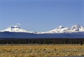
Anyway, the 133 mile trip to Bend wasn’t fast. The roads are posted at 55 mph but have many curves ranging from 35, 40 and 45 mph. We weren’t in any hurry and really enjoyed the scenery near the road- the mountain peaks normally seen were hiding behind that danged smoke! It’s supposed to clear out in a couple of days. I sure hope so since we’ll be here for five!
