The Henry Ford Museum- WOW!

Thursday September 28, 2017- Trip Day 55

This campground at Wayne County Fairgrounds has quite a mix of folks. Some are full time RV’rs, some are like us, visitors. And some are here with their entire families which include young kids.

Wayne County Fairgrounds RV Park

The latter campers obviously are here to work. Dad leaves in the morning in his work truck, mom and little kiddies stay here in their home on wheels. Some kids are school age and I don’t really know if they are being home schooled or go off to public school.

Henry Ford, Greenfield, Folks That Ford Revered

P1050607

Disassembled Ford Model T

A big day is planned. Megan is going to doggie day care where she will get a bath and make new friends at a brand new place to her. While she is being cared for we are going to visit the Henry Ford Museum of American Innovation and Henry Ford’s Greenfield Village, more formally known as the Edison Institute. Ford’s vision was to preserve items of historical interest and portray the American Industrial Revolution.

Ford said of his museum: “I am collecting the history of our people as written into things their hands made and used…. When we are through, we shall have reproduced American life as lived, and that, I think, is the best way of preserving at least a part of our history and tradition..”.

The Kennedy Car/ An Original Copy Of Declaration of Independence

The Rosa Parks Bus/ Chair Lincoln Was Sitting In When Shot @ Ford Theater

The entire complex sits on 260 acres of land located near the Ford Rouge Plant where plant workers are making Ford 150 trucks. One may tour that plant also. The 12 acre indoor museum includes machines that sparked the American Industrial Revolution through mass production, events, articles and items of interest from early American History all the way through the 1970’s.

Greenfield Village was created by Henry Ford to display structures of historical significance in a beautiful town-like setting. It’s really an outdoor living history museum. Horses drawing wagons go clip-clopping by. Various models of Model T Fords transport visitors around the 260 complex.

P1050778

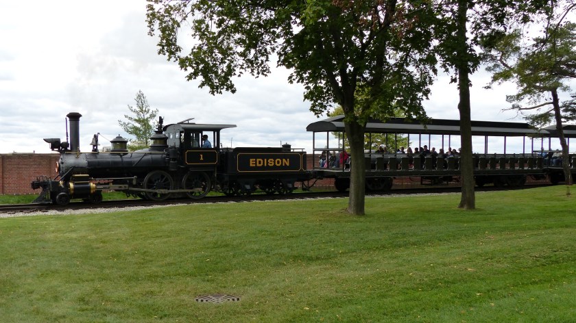
A steam locomotive pulls passenger cars full of visitors around the perimeter of the park. Docents dressed in period garb do an incredibly good job of explaining and demonstrating what life was like or the workings of antique machinery.

P1050845

We ate lunch at the vintage 1850’s Eagle Tavern, enjoying pea soup made from a period recipe- it was delicious!

Many of the homes in Greenfield are either the real McCoy or exact replicas of buildings that Ford felt significant. His own house, that of Robert Frost, Luther Burbank’s birthplace, you get the idea. He even brought the Ferris Windmill from Massachusetts which is said to have been built in the 1600’s.

Ford’s close friend and previous employer was Thomas A. Edison. As time passed their friendship grew. They even vacationed together in Florida. As a tribute to Edison, Ford had much of Edison’s factories and shops to Greenfield. I have to say both men were incredible pioneers of the American Industrial Revolution.


The White House in the Lower Photo is Ford’s Place of Birth

Anyhow, enough blabber. I took 360 photos at the museum. I will not share all of them- but plenty of them!

Washington’s Camp Bed/ Famous Underground Conductor Harriet Tubman/

Frederick Douglas

More Photos- Enjoy!


Below: A Few Photos of the Edison Institute

P1050862

We’re In Detroit…….. Sorta

Wednesday, September 27, 2017- Trip Day 54

Unknown

OK, so we’re not in Detroit nor do we plan on going into downtown Detroit. We are in Belleville at the Wayne County Fairgrounds RV Park, a measly 17 miles from downtown Detroit. As some of you are aware ya takes your chances when it comes to fairground RV Parks. Sometimes they aren’t so nice, this one is. Lots of grass for our muttzo Megan’s walks. The RV sites are grass. The only ding that I can see is the sites are side by side- one utility pedestal is shared by two rigs.


Wayne County Fairgrounds RV Park

So far we have one neighbor so we are sharing the common space between us. So far that’s not a problem as our neighbor is “camping” in a covered utility trailer full of picker junk….. er…… rusty treasure. He’s on his way to Hershey PA to attend their swap meet. By the by, we were here by 1030 hours and the lady in the office did not charge us an early arrival fee!

After setting up and enjoying a tomato soup lunch we took a ride to downtown Belleville (3900 souls). The town was platted in 1847 with the main thoroughfares still used today. Large expanses of woodland were removed to make way for farmland, industry and an increasing population so this town was initially a lumber town.


Contrast: Belleville Lake- Before our arrival and during our visit

There was a need for electrical power so the Huron River was flooded early in 1926 creating Belleville Lake. The town’s claim to fame is the National Strawberry Festival.

It’s still fairly early. Let’s go have a look at Ypsilanti (19,000 souls). For those who are pronunciation impaired, the “Y” in Ypsilanti is pronounce as an “I”, as in ip-si-LAN-tee. It’s named after Demetrios Ypsilantis, a hero in the Greek War of Independence.


The city is only 9 miles west. Originally a trading post established by the French Canuck Gabriel Godfrey in 1809, a permanent settlement was established in 1823. The town played an important role in the auto industry. From 1920 to 1922 Apex Motors produced the “ACE” car. But Preston Tucker whose family owned the Ypsilanti Machine Tool Company, designed and built the prototypes for his Tucker ’48.

P1050939

1948 Tucker

In 1945 Henry J. Kaiser and Joseph Frazer bought the nearby Willow Run B-24 Liberator bomber plant from Ford Motor Co. and started making Kaiser and Frazer model cars in 1947. The last Kaiser rolled off the assembly line in 1953. General Motors purchased the plant an converted to its Powertrain division. That division shut down in 2010.

Ypsi has an interest political history. In the 1970’s the penalty for the use and sale of marijuana was reduced to $5 via initiative. When a fella was prosecuted for possession 100 pounds of cannabis the defense argued that he should be charged under Ypsilanti’s ordinance. Cooler head prevailed and the judge declared the ordinance invalid.


Interesting signage in Depot Town, Ypsilanti MI

Also in the ’70’s a Muslim native of India was elected to the Ypsi city council, a first in Michigan. In the ’90’s Ypsi adopted a living wage ordinance, and a housing discrimination ban. Driving around town we saw more signs of progressives- black lives matter, sanctuary churches, women’s rights and “resist” signs. I ask resist what or who? Can’t we all just get along?


More Ypsilanti

Can you tell by it’s political history that this progressive little city may also be a college town? Yep- Eastern Michigan University. We head back to camp and settle in for the evening.


Willcommen- Es ist sehr heiß heute!

Tuesday September 26, 2017- Travel Day 53

P1050558

Willcommen!

German to English translation: Welcome- It’s hot here today! And boy, is it. It’s as warm as yesterday with temps pushing 90 degrees with 50% humidity. Real feel is 101 degrees. Whew! And to top it off our coach here Pine Ridge Camp Ground, Birch Run is sitting in full sunlight absorbing all the heat ol’ Mister Sun can muster. It’s my fault. I requested a site where our satellite system would work. We arrived at 1030 hours- two hours before check in time. No one was in our site…. so we got scolded again for early check in and charged $5 extra. I said to the lady at the desk that since we would be leaving 3 hours before check out time would we get our 5 bucks back? Notta chance cowboy!

Yesterday we spent the evening in Harrison (2400 souls) at the Hill Top Camp Ground. Harrison was founded as a lumber town, with sawmills located on the shores of Budd Lake.


Hill Top Campground/ Art at Rest Stop

One of the lumber companies donated the land which is now Wilson State Park. The City of Harrison attracts thousands of visitors from throughout the state, with its “twenty lakes in twenty minutes” and large amount of state land for recreational sports. The most popular local events are the Clare County Fair and Frostbite Open Golf Tournament on Budd Lake.

The reason for the German language title is that we are in Frankenmuth Michigan, pop. 4900. The town was founded by German immigrants in 1845 who came from the Province of Franconia in the Kingdom of Bavaria. The name means “Courage of the Franconians”. Today she is also affectionately known as Little Bavaria or Muth.


Zehnders Famous Chicken Dinners Also Served At Bavarian Inn

The nearby villages of Frankenlust, Frankentrost, and Frankenhilf (now known as Richville) further illustrate that the area remained a magnet for other Germans emigrating from the same region. German, and in particular, the Bavarian culture of the town has been preserved and passed down through the generations. The German language is still prevalent in signage and speech. Even today, there are German-speakers residing in the town. The church of St. Lorenz offers monthly services in the German language.


Frankenmuth is Farm Oriented 

The original Frankens would not recognize this place. It’s a very touristy town, the architecture very much that of nuevo Bavaria. Looking at the size of the parking lots, this place receives a lot of visitors. Luckily we’ve come off season and on a weekday so the crowds not so much.


Mural, Plaque, Park Field Haus

Coming into town from the south the first business we see is Bronner’s CHRISTmas Wonderland. And boy, is it! It promotes itself as the worlds largest Christmas Store and I will not dispute it. Bronner’s parking lot can accommodate over 1,000 cars and 50 buses. Some 100,000 lights illuminate Bronner’s half mile long Christmas Lane in the evening. On the Bronner property is a replica of the Oberndorf, Austria, Silent Night Memorial Chapel as a tribute to the Christmas hymn “Silent Night”.


Bronner’s and Replica of Silent Night Chapel

Driving through downtown Frankenmuth is reminiscent of a drive through a Bavarian town- except for the 4 lane main street with American built cars whizzing by. There are lots of stores featuring items not remotely related to Bavaria. Clothing stores, pet supply stores, ice cream stores, popcorn store? Okay, Bavarian style pastry shops and chocolate shops are here too. One can take a ride on a small stern wheeler down the Carr River.


Most Stores Not So German Culture Oriented 

And the town has a whole lot of up scale, very large hotels, inns and I don’t know if one can call anything in town a motel. One of the largest is the Bavarian Inn Lodge, a 360 room, 4 swimming pool, indoor 18 hole miniature golf establishment that features nightly entertainment, 2 gift shops and two restaurants!

P1050548

Bavarian Inn Lodge

And there are many others. The Zehnder family owns the  and Zehnder’s of Frankenmuth which is famous for it’s all you can eat chicken dinners. The restaurant seats 1500 folks while the Bavarian Inn seats 1200- no wonder the parking lots are so large! By the by, the Zehnders also own Splash Village Hotel and Waterpark, Zehnder’s Marketplace, and maybe even The Fortress, a championship golf course.

Tomorrow we’re moving towards Dearborn Michigan. See you there!


We Are In The Deep South….. well, it feels like it!

Saturday, September 23, 2017- Travel Day 50

P1050512

So while our mountains in the Reno area are being hit with blizzard conditions we, in lovely Lake Leelanau Michigan are sweltering. Record highs have created us the last two days. Temperatures in the mid 90’s with 90 percent humidity tapering to 40 percent by sundown makes for some pretty uncomfortable weather. Thank goodness our new air conditioner is keeping up with the heat.

We drove a helter skelter course from our first stop of the morning, Friday September 22nd, the Riverside Tire Company. I visually check our tires, all eight of ‘um, at every stop. I check tire pressures frequently also. Well, one trailer tire looked a little peculiar, no, a lot peculiar as half the tread was worn flat down to the nubb on just half the circumference of the tire. Uh oh. Anyway, The others weren’t in the best condition so Riverside tire ordered four new tires for us and had them the next morning. By 0900 we had packed our bags, gone to the tire store, the new tires were mounted and balanced and back on the coach. Great service and a decent price for the tires at that. Thanks guys!

Back to the craziness of getting back to highway 31. I looked up our route on Google Maps the night before we left and wrote down the directions. I set the destination in the truck’s onboard navigation system. Jil sets our destination on her phone. We can’t go out the easy way because we would have to take the Ironton Ferry across an arm of Charlevoix Lake. Length limit for trailers on the ferry= 16 feet, our trailer is 34 feet. Do you see the same problem here that I see? Anyhow, my hand written directions, the truck’s navigator and Jil’s “smarty” phone do not agree on the route! They don’t agree on any of the roads on our way back to highway 31. Crap! Anyhow I’m trying to ignore all the cyber chatter “When Possible, Make A U-Turn“, or “Turn Left In Three Hundred Feet”. One machine says make a u-turn while simultaneously the other says turn left. Good Grief!

Anyhow, we somehow make it back on to highway 31 and turn south towards Traverse City. And what’s the first thing of interest we see? A big ol’ farm store, that’s what.

P1050506

We pull in and have a friendly chat with the proprietor who also lives on this family farm. We buy fresh apples and, wait for it,…….. farm fresh pasties! They are precooked by the farmer lady and fresh frozen. We purchased two, one traditional meat, veggies with the traditional rutabaga included, and a breakfast pasty, sort of like a breakfast burrito.

We travel through rolling farm country until we get to the end of Traverse Bay, then swing west through the busier that it ought to be Traverse City for a city of 14,000 souls. She is the seat of Grand Traverse County and the largest of the 21 county northern Michigan region. FYI- the area is the largest producer of tart cherries in the U.S.

Unknown

Suttons Bay

The route we are taking will lead us around the east and west arms of Traverse Bay and up the west side of the west arm to Suttons Bay where we head inland a few miles to our camp for two nights, the Wild Cherry RV Resort. Confusing I know, but think of it as two fingers sticking up into Lake Michigan.

P1050507

A Big Wind Event Followed This Cloud Formation

We manage to get through town with nary a scratch but I’ll tell you these Michiganders are crazy fast drivers! The are oblivious to red alert situations- like pedestrians who are already halfway across the street which are totally ignored by oncoming drivers. On the other hand I’ve seen pedestrians walk right out in front of quick moving traffic. We emerge from the city. Luckily for us we find that highway 22 has multiple areas of road construction delaying our arrival by about 30 minutes. No big deal……….

Wild Cherry Resort is absolutely beautiful. The park has two tiers and we have been assigned a site in the lower with a big pond right behind our coach. The sites are wide with grass between them. There’s a treed area across a grassy field where we can run Megan. In other words, a perfect park for us and our Muttzo!

Wild Cherry RV Resort

While here we’ve done some exploring. We’ve gone to Lake Leelanau and its namesake township and to Leland. Lake Leelanau is a large lake on the peninsula that separates the main body of Lake Michigan from Traverse Bay.

Lake Leelanau- St. Mary’s Church & Auditorium

Leland is on the eastern seaboard (lake board?) of Lake Michigan. Leyland on the eastern shore of Michigan and Suttons Bay on the west bank of the West Arm of Traverse Bay are real touristy places- but nice.

Historic Fish Town, Leland Mi

Neither one of their business districts are more than two blocks long. The merchants obviously are catering to the tourist crowd but each are fun to visit.

Downtown Leland, MI

Next we are heading southeast towards Dearborn and Detroit. See you there!

On The Shores of Lake Charlevoix

Wednesday, September 20- 21, 2017- Trip Day 48

P1050475

We moved this morning the grand distance of 60 miles to the shores of Lake Charlevoix. Boy, these French origin words are not hard to pronounce but hard to figure out how to pronounce. Charlevoix is pronounced “Sharl-eh-voy” in case you are interested- it’s pronounced the same even if your not.

Boyne City and Harbor/ Horton Bay General Store

Lake Charlevoix is located on the eastern shore of Lake Michigan. In itself it is a large lake, the third largest in the state at over 17,000 acres and 52 miles of shoreline. Many sources of water inflow including the Jordan and Boyne Rivers flow and the short outflow travels through Round Lake/Pine River complex into Lake Michigan.

We made reservations at Young State Park for two nights. This park is on the south east shore of Lake Charlevoix about four miles from the town of Boyne. No more than 10 sites were available so I grabbed the one that didn’t require a 100′ long power cord yet might afford satellite reception- site 162.

Our Site- Three out of Four Loops Look Just Like This!

I fully expect the campground to be fairly full when we arrived but the my surprise approximately 30 sites out of 240 are occupied and 25 of those are not within our line of sight! Anyhow, we get set up and have no problem receiving a TV satellite signal.

We drive the short distance to the Boyne City (3700 souls). I could find little on the history of the town other than a few references to logging camps and a railroad. One thing is certain though. Two New Yorkers were the first permanent settlers. Harriet Miller told her husband John that she had a dream about living on a bear shaped lake located west of New York with a cabin on the east end of it. Determined to follow her dream she convinced John to sell their home and set out to find this strange new place. After making their way to Northport they persuaded John Saxon Dixon to take them to the east end of Pine Lake. To their astonishment they found an abandoned cabin there just as Harriet had seen in her dream.

Ironton Ferry- Our Steed’s Fee Was Three Bucks

We had a two night stay here. The first was a travel morning with a sight seeing tour into Boyne in the afternoon. Today we drove around the entire lake. I’ll qualify that by saying part of the drive included an unexpected 250 yard ferry ride. It was either pay $3 for the ferry or burn $10 worth of diesel fuel going back to a connecting road. The ferry ride was relaxing actually. We drove to the town of Charlevoix (2500 souls) which is located at the west end of Lake Charlevoix.

Downtown Charlevoix, The Harbor, Megan Enjoying The Fountain as Jil Looses Her Head

This city is the seat of Charlevoix county. It’s another one of those cookie cutter turn of the century town. You know which ones I mean. Most buildings downtown are two story, the majority of them made of brick. This town is like Boyne as it is built right on the lake shore. It’s a little more touristy however. A farmers market is going on right on a green way on the main drag and a group of motorcyclists are enjoying the downtown shops. Traffic is pretty heavy, especially since road crews have the main road torn up with detours in place.

Really Nice Homes, An Inn And A Drawbridge In Charlevoix

Another thing they have in common is their beautiful homes. Both of these towns remind us of little towns on the eastern seaboard.

We are moving on tomorrow. We plan on staying at the Wild Cherry RV Park near Suttons Bay. See you there!

The Wind Is Blowing, The Sea…er… Lake is Rough- Shall We Go?

September 19, 2017- Trip Day 46

P1050392

Most taxis provide transportation to the Grand Hotel

The reason most folks come to St. Ignace is to catch a ferry to Mackinac Island. We are most folks so this morning we board a Shepler’s Ferry, in this case a high speed double decker passenger boat that may hold as many as 150 passengers. Fair is $26 round trip per person. The wind is blowing and Lake Huron resembles the Pacific Ocean. Four foot seas have been whipped up. It’s a 14 mile round trip. The ferry leaves each port on the half hour this time of year- low season. We get a treat on the way to the island, a side trip to the Straits along with a view of east and west sides of the Mackinac Bridge as we float underneath.

Views of Mackinac Bridge- Left- From Lake Huron, Right- From Lake Michigan

Heading Towards The Bridge/ Coast Guard Vessel

Approaching Mackinac Marina

The ride is remarkably smooth with a following sea to the bridge then directly into the sea as we head toward the island. We are sitting on the bench seat most towards the stern which affords a smoother ride than those that are sitting up near the bow. The boat enters Mackinac Harbor where now the swells are coming in from starboard- the boat rocks side to side as we approach the dock. We brought our Muttzo Megan with. To our knowledge she’s never been on any kind of boat. At first she is very nervous, then settles. Atta girl!

P1050424

Mackinac Island was a center of fur trade back in the day. As a place of “strategery” Fort Mackinac was built by the British. Two battles were fought here during the War of 1812. Today it’s all about tourism. The Grand Hotel is magnificent. In fact, just to enter the hotel if one is not a guest will cost one 10 bucks.

Beautiful Old Homes Overlooking Bay/ Island House Built Around 1862/ P1050394Even The Trash Is Collected By Horse Drawn Wagons

Most of the buildings here are vintage 1800’s. Grand homes dot the island. No motorized vehicles are allowed during the summer months with the exception of electric scooters for the disabled. If you want transportation other than foot power horse drawn taxis are available, bicycles are available for rent or bring your own bike. You can even rent horses and horse drawn buggies! Rules change somewhat in the winter when snowmobiles are allowed.

Post Office/ “Police Only” Bike Rack/ City Hall

Mackinac is liking walking back in time. Beautifully maintained vintage buildings are the norm. We love the clippity clop sound of horses hooves as the taxis pass by. The place is just gorgeous. Even though we are visiting in shoulder season, there are too many people here for our taste.

P1050460
Up to 50,000 visitors a day come to Mackinac Island

We spend several hours just strolling along the narrow streets and gawking at the great architecture of years past.

P1050459
Fort Mackinac Circa 1780

Our ferry ride is a little shorter heading straight back to St. Ignace- no detour to the bridge. We really enjoyed our tour of Mackinac Island. Not to take anything away from Mackinaw City or St. Ignace, who in themselves are a great place to visit, but Mackinac Island is the proverbial icing on the cake.

Livery Sign/ Governor’s “Summer Mansion”/ Windermere Hotel

Tomorrow a new adventure awaits. We are heading to Young State Park in Boyne, MI.

Anishinaabemowin

September 18, 2017- Trip Day 45

P1050358

Star Line Hydro Ferry- Destination Mackinac Island

Anishinaabemowin- the language of the Ojibwe people. Betcha didn’t know that! Unlike many languages this one has not been lost. The University Of Minnesota’s Department of American Indian Studies, University Libraries maintains an extensive Ojibwe language dictionary. The reason I bring this up is a roadside historical marker was in English on one side and Anishinaabemowin on the other.

P1050340

Language of the Chippewa

We are in St. Ignace on the north shore of the Straits of Mackinac. The Straits connects Lake Michigan with Lake Huron- our third Great Lake this trip. The three mile long Mackinac Bridge connects Michigan’s Upper Peninsula with the Lower Peninsula also known as The Mitt.

P1050346

Mackinac Bridge Looking Towards Mackinaw City

If one looks at a map of Michigan the area between Lake Michigan and Lake Huron looks like a mitten. Interstate 75 ends in Sault Ste. Marie and runs through St. Ignace. When we left Sault we chose to take secondary roads to our next campground, Lakeshore RV Park Campground locate a couple of miles west of downtown St. Ignace. The route takes us first through farmland with a little dairy thrown in, then through thick cedar forests. Weather resistant cedar is a big industry here. It’s used for roofing shingles, fencing, and outdoor furniture. As usual the route takes us very close to our third Great Lake, Huron, but we see little of it for the trees.

Castle Rock- A “must see” tourist trap

After a pleasant drive the road takes us to a port on Lake Huron- St. Ignace (2400 souls). She is the seat of Mackinac County and gateway to the U.P. for travelers from the Lower Peninsula.  Fully one third of her population identify as Native American. The Mackinac Bands of Chippewa and Ottawa are headquartered here and the Sault St. Marie Tribe of Chippewa Indians runs a casino just outside of town.

The more we travel the Great Lake Region the more we hear of the Frenchman, Father Jacques Marquette. He founded the St. Ignace Mission in 1671. Earlier he had founded a mission in Saul St. Marie. Marquette was not only a missionary, he was an explorer. He joined Louis Jolliet and departed St. Ignace in 1673 with two canoes and five voyageurs on a voyage to find the Mississippi River.

Voyageurs were sort of the Rambo’s of the fur trade and water transport world. A voyageur hired on a the age of 21 was expected to carry three 90 pound sacks a half mile from one portage to the next. Some could carry five or six! And they didn’t retire until into their sixties. This missionary explorer and Joliette actually found the Mississippi River after following the Fox River out of Green Bay to the Wisconsin River, then to the Mississippi. The followed the Mississippi all the way to the confluence with the Arkansas and would have gone farther but started seeing signs of Spanish influence and turned back.

Father Marquette grew ill and died in 1675 at the age of 38. He was buried where he died near Ludington, MI. At a later date his bones were disinterred and brought to St. Ignace and buried at the mission a place that he truly loved.


The Soo Locks

September 17, 2017- Day 44

P1050299

Sault Ste. Marie, Ontario, Canada As Seen From Aune-Osborn Campground

We are in Sault St. Marie Michigan, a town of 14,000 souls. Across the St. Mary’s River is Sault St. Marie, Ontario Canada, a much larger city of 74,000 souls. Father Jacques Marquette established a mission at what was a Native American village back in 1668 Sault one of the oldest establishments in Michigan. French colonists later set up a fur trading post followed shortly by a settlement as the fur trading business grew.

Our Campsite/Chippewa County Courthouse/ View Towards International Bridge

We are staying at Aune-Osborn Campground located downriver from the Soo Locks and we can view ships passing in both directions. Nothing lies between us and the water but a narrow band of grass.

P1050311

A Freighter Passes By Aune-Osborn Campground

Before locks were built canoes and cargo had to be portaged around the 21 foot high rapids that connected Lake Superior to Lake Huron. Lake Superior is 21′ higher than Huron, you see. The first lock was built in 1855.

Sault Ste. Marie Is Located In The Narrows In The U.S./Canada Boundary/Soo Locks

The current Soo locks can accommodate a 1000′ long lake freighter. It’s also the world’s busiest canal by tonnage. A great number of freighters passing through the locks carry iron ore. Interestingly, the large lake freighters are landlocked as the Welland Canal that bypasses Niagara Falls is limited to ships longer no than 740′. The freight is transferred from “lakers” to smaller seagoing ships known as “salties”.

Ok, before we set up camp I tried to contact the fella that had ordered the front landing gear motor for our coach. And I tried again, left a message, and even drove to his place of business but no one was there. He is supposed to open at 10 a.m. Down the street a quarter mile is a Walmart so we went over there to wait and do a little shopping. I called again at 11 a.m. and he answered. It took all of one minute to drive back to the shop, and 30 minutes to replace the motor which included time finding it in his dirty, cluttered shop. The shop keeper was a nice guy. He works part time for the Michigan Department of Natural Resources as a seasonal firefighter so we had a little in common to talk about. The nice thing is that he didn’t overcharge and the new motor cured the problem. Thanks fellow firefighter!

Saul Tower and Ship Museum

Back to Sault St. Marie. We went to church this morning at St. Mary’s. The midwest has a lot of beautiful churches and this is certainly one of them. Mass was wonderful. The pastor is an avid gardener and can be frequently found getting his hands dirty on the church grounds. He is also an excellent photographer. We had plans to go up into the 210′ Tower of History but weather came in and it started to rain and blow pretty hard. Not good picture taking weather. The Tower which offers a 360 degree view. It was originally built in 1968 by the Catholic church as a shrine to past missionaries such as Bishop Baraga as part of a master plan. The plan didn’t materialize and the tower was donated to the Sault Historic Sites.

Temperatures have dropped from the 80’s and muggy yesterday to the low 60’s, cloudy and windy this evening. We had a downpour that flooded portions of the campground. That gave us an opportunity to take full advantage of the little laundromat here in camp. No one other than us seemed interested in using the facility which helped us expedite our clothes washing chore.

We’ve watched at least a dozen freighters pass our campground here on St. Mary’s River- from our coaches window!. There have been lots of pleasure boats too. And to top off our visit at Sault a water dropping Super Scooper twin engined seaplane made a few passes, scooping up a tank load of river water and dumping the water upriver. What a treat! I’ve seen the same type of plane scoop water from the Pacific Ocean and dump it on a brush fire in the hills of Malibu, CA.

Tomorrow we head south to the Mackinaw area. See you there!

P1050326

Our First Sunset For A Long Time!

Talka Whatthe Hecka Menon Falls….. or something like that.

Saturday September 16, 2017- Travel Day 43

P1050231

Upper Tahquamenon Falls- Notice the folks on the right hand side of the brink for a perspective of the size of this fall. Color of water is caused by tannin.

Sixteen miles up MI 123 is Tahquamenon Falls State Park. Tahquamenon is an Ojibwa word meaning “dark berry”. The falls is significant not only for its beauty but for its size. The 200 foot wide and fifty foot tall upper falls flows up to 20,000 gallons of water per second.

Scenery around Upper Falls

That makes it the second largest fall east of the Mississippi River second only to Niagara Falls. It doesn’t look as large as it is until one sees people standing beside the brink.

The lower falls splits around an island and is more like a cascade. The scenic beauty of the Yooper Peninsula is wonderful but these two waterfalls are my favorite this far. We celebrate our great fortune by purchasing two waffle cone ice creams. Jil had a mint chocolate chip with the chocolate was in huge chunks, not chips. I, on the other hand, honored Tahquamenon Falls with a dark cherry ice cream cone……. you remember Tahquamenon means “dark berry”, well cherry is not berry- but close enough!

We travel next to Paradise, which is on the north eastern coast of Lake Michigan. Jil wants to go to the Great Lakes Shipwreck Museum. Why, I ask. Because I do, she replies. Never argue with the boss.

Whitefish Point Light Station, circa 1864

Sooooo, we take a left in Paradise and head towards Whitefish Point Light Station and the shipwreck museum. The museum is located on the light house grounds. Several of the original buildings still exist and are meticulously maintained. Four buildings are open for self guided tours with a docent in each. And one has be converted into a B&B.

Notice the Second Story Bridge From Home to Light Tower

Jil wanting to go to the museum turned out to be a very good “want”. The shipwreck museum is small in size but large on explaining the history of shipwrecks both hundreds of years old to modern day. Most were caused by nasty storms that whip up the Great Lakes to ocean proportions. 25 foot seas and 60 knot winds is significant for any vessel.

Museum Pieces/ Center bottom: Original aerobeacon lens 8′ in diameter!

A lot of the ships were torn in two. Records indicate at least 550 ships have gone down, approximately 200 of them off Whitefish Point. The area between here and Munising is known as the Shipwreck Coast. All ships entering or leaving Lake Superior must pass Whitefish Point, making this light the most significant of all. The rest of the tour is through the light keepers house, another home that is used as a gift shop, the boathouse and a small building used as a theater. The crew’s quarters is now a B&B.

Light Keepers House

The light in the lighthouse was lit by oil lanterns and the clockworks that turned the light had to be wound every 2.5 hours. Talk about job security! The light keepers home was attached to the light tower via an enclosed, elevated walk accessed from the second floor. We thoroughly enjoyed the Tahquamenon Falls, the Great Lakes Shipwreck Museum and the grounds of the Whitefish Point Light Station.

We spent the night at the Bay Mills RV Park in Brimley. Bay Mills is on the Chippewa Reservation and associated with the Casino across the street. Tomorrow we have a very loose “appointment” with the owner of Sault RV & Trailer Sales/Service to get our malfunctioning landing gear fixed.

We Are In The Land Of The Yoopers!

Thursday September 14, 2017- Travel Day 42

P1050197

Tuesday we left the really really Quietwoods RV Resort ghost town, not because we didn’t enjoy the tranquility but we have more of the Great Lakes region to explore. We head towards Green Bay and up the west shore of Lake Michigan. Our destination is less than 90 miles away- Menominee MI.

On the way we stop in Peshtigo, a small town infamous for a forest fire that burned in and around town back on October 8, 1871 killing 1200 and as many as 2500 souls. We visited the museum dedicated to telling that story. According to accounts the fire swept into town very quickly catching the townsfolk off guard. The ensuing firestorm was said to have had winds reaching 110 mph and flames reached 2000 degrees. People jumped into the frigid Peshtigo River to save themselves and loved ones. Some of those drowned or died from hypothermia. In all 12 communities were destroyed and the land was scored for 1800 square miles. Ironically, it was not the only major fire that occurred on this day in 1871. A fire occurred on the Door Peninsula, the Great Chicago Fire as well as others around Lake Michigan.

Peshtigo MI Fire Museum

Menominee (8500 souls) is located just across the Marinette River from Marinette WI (10,000 souls). Marinette looks like a thriving community, Menominee not as much. One of the locals told me that a lot of businesses are moving from Menominee to Marinette- could it be a tax issue?

Downtown Menominee MI

We stayed at the River Park Campground. Its another well kept municipal park that we’ve had the fortune to find. So many of them along the coast of Lake Superior and now Lake Michigan.

20170912_164513 (1)

Looking across the river we see four large gray vessels. What the???? The Marinette shipyard is producing naval vessels. They are special ships that are smaller than destroyers that are designed to work in the littoral (close to shore) zone.We explore downtown and vicinity, stay one night and are on our way Wednesday.

Our next destination will be Marquette (20,000 souls) Marquette is the largest town in the Upper Peninsula of Michigan. The land of the Yoopers! Here lies a large population with Finnish heritage, and some German. They have a little different pronunciation of the English language, “der” for “there” and others. Yup is used a lot as well as “you bettcha” and even “Okie Dokey”. They tend to be very friendly people who will talk your ear off- my kind of folks.

St. Pete Cathedral/ Abandoned Ore Dock/ Downtown Marquette

After a Mister Toads Wild Ride through downtown Marquette with a few road work detour caused road closures, a visit to a local business to ask how the hell we are to get to our campground for the night- Visitors Campground, we finally drop anchor. Aaannndd, the front jacks on the RV won’t go down without blowing a fuse. We finally get unhitched after blowing 3 more fuses. Crap! I’ve run out of 30A fuses so I have to find an auto parts store to purchase more…….. just in case. So in order to raise the front of the trailer to get hitched to the truck again the onboard motor won’t do the job. What will is my 6 ton jack but I also need a way to retain the gained elevation the jack affords. I need jack stands.

All of Marquette’s major streets seem to have a road construction detour or closure. The town is not easy to get around in to begin with and now with the closures even more so. I try to avoid the road construction and associated traffic only to find that streets that appear to got through go over the street I want to get to. More crap. The first auto parts place doesn’t have what I need, the second does. Heading back via the “short cut” around downtown just puts me in a 20 minute lane closure delay. More crap.

I usually get up at 0600 to 06300- when daylight wake me up. I get up before the sun appears- and it’s 0730! We are in Eastern Daylight Time, now our fourth time zone. After readying ourselves for the day I proceed to jack up the front of the trailer with the bottle jack, jack stand holding the elevation gained. One side, then the other goes up until the fifth wheel hitch and pin box match. We hitch up without a problem. Now to find a place that can help remedy our problem with the landing gear jacks.

We somehow escape Marquette with nary a scratch and never got twisted around by all of the detours. We head out of highway 41 backtracking to highway 24. We stopped at Munising (2300 souls). This town is very picturesque with a very nice downtown and very clean. A ferry can take you to Grand Isle from here and the town is a jump off point for Pictured Rocks National Lakeshore. Multiple water falls are in the area. And one can buy home made pasties (short “a” like in “at”)- a local favorite that is a sort of a stew filling in a pastry dough then baked until golden brown. We’ll have to try one!

21731144_10213762667321710_519541110171069966_n

Downtown Munising, MI

Unfortunately we can’t stay. I’ve found a repair shop in Sault Saint Marie who is willing to help me figure out what’s wrong with the landing gear Saturday. The only town of size within 35 miles of Munising is Seney. During its white pine logging heyday Seney had grown to 3000 souls, today there are 200.

Newberry, MI

We turn left onto Michigan 123 and drive through Newberry (1500 souls). The village is the seat of Luce County and southern gateway to Tahquamenon Falls State Park. Pulling into Kritters North Country Campground we realize we’ve made another good choice to overnight.


The Shrine of Our Lady of Hope and Lambeau Field

September 11, 2017- Travel Day 39

21557612_10213740537088468_3893872004589028238_n

I believe I mentioned how much quieter the campground is compared to our first night on Saturday. Well the place has turned into a veritable ghost town. The only people here are out of towners- all six of us- Jil, our muttzo Megan, myself and 3 others that we know of. This park has 175 sites- about 1/4 of them still have trailers but no vehicles. It’s so quiet it’s spooky. What do they know that we do not. Are we at ground zero? Was it something we said or did? Almost all the people that camp at Quietwoods are locals from around the Green Bay area. They come here on weekends, then go home Sunday afternoon. Some leave their trailers here, most take them with. Like an old camp host once said “Its the Hoover effect. It’s like Sunday afternoon a big Hoover vacuum sucks everybody out of camp”.

The whole purpose of us coming to Door County and the inspiration for the trip to the Great Lakes was to visit the Shrine of Our Lady of Good Help located in nearby New Franken.

Our Lady of Good Help Shrine

The shrine sits on peaceful farmland surrounded by- farms. This area was settled by Belgian immigrants. The site preserves the spot where the Queen of Heaven, St. Mary, appeared to a young Belgian immigrant woman named Adele Brise in 1859. The Message of the Blessed Virgin was simple: Teach the Catholic Faith to the children of a people who were losing their faith through neglect. Sister Adele took the message to heart and for thirty-five years dedicated her life to this mission. She would do this by traveling as far as 50 miles on foot up and down the Green Bay Peninsula. It’s quite a story of dedication from a very dedicated woman.

The shrine is the only place in the U.S. that the Vatican has recognized as a legitimate appearance of St. Mary. And Mary appeared not once but three times, the first scared Adele- then it happened the next Sunday. The third appearance Adele asked who the beautiful lady was….. the reply was “I am the Queen of Heaven” and then gave Adele instructions to teach the children. “Teach them what they should know for their salvation”.

P1050142

We enter the Shrine and one feels a sense of Her presence. As if St. Mary is here. This day also coincides with the 9/11 attacks 16 years ago. Jil and I silently pray for all those who were personally affected by the loss of a loved one, their loved one, and for those who were involved in the search and rescue effort be they civilian or uniformed. We also pray for those who are needy economically and spiritually. We do this not knowing that our life partner has prayed for the same.P1050123

Directly below the altar in the chapel is the Shrine. Even if you are not religious this place will feel special. Outside is a small cemetery where Sister Adele is buried and a large beautiful grassy area surrounded by a gravel path. The center of the grassy area are the Stations of the Cross, in one corner is a memorial to September 11, 2001- “We Shall Never Forget”. Signage mentions an old Belgium tradition of building a small shrine on ones’ property and by golly we find one in the front yard of a farmhouse in Brussels. It building measures no larger than 6’x8′. Inside an unlocked door is the shrine. A very old guest book lies under the newer one so that all visitors can look back in time to see who visited , when they visited and from where they hale.

Downtown Green Bay is only 13 miles from New Franken- let’s go! I-41 is elevated so we can see our target- Lambeau Field, home of the Green Bay Packers football team.

Unknown

The people own the Packers team. That came to be in 1922 when the teams finances were on hard times and the Chicago Bears refused to play in Green Bay because they weren’t guaranteed the box office fee of $4000. The cash strapped team realized they had to raise cash somehow so they offered stock at $5 a share- buy 5 shares and a season ticket was included. So the shares are now sold for $250 when offered- which isn’t often. The last sale was for upgrading Lambeau Field. Owning Packer shares offer no season ticket privileges, no dividend, can’t be sold- no nada………. but you can transfer your shares to your kid!

Lambeau is a thriving business. We are there the day after game day. The visitor parking lot is nearly full. Inside the Atrium are shops and several docents offering guided tours. This place is here because all of Green Bay loves the Packers and are proud of their stadium and rightfully so. This place is amazing!

We head back to the ghost town of an RV park and do some wash. Two washers and two dryers in the wash house and they are all ours. Our clothes are washed, dried and folded in no time at all. Tomorrow we’ll travel to the other side of the Green Bay and start heading back towards the U.P.- Michigan’s Upper Peninsula.


Here a Cheesehead, Everywhere a Cheesehead?

September 9, 2017- Travel Days 37 & 38

P1050072

We’re in GREEN BAY!

September 9– Our travel day is only 107 miles. We leave Antigo and head south on Wisconsin 45 to Wittmer where we transition on to the combined east bound highways 45/29. Its a four lane divided highway- the truck lane is a little beat up but serviceable. Our destination for the day is Bay Shore County Park Campground located in Door County- a highly desirable destination. It doesn’t take long to get to the greater Green Bay area. Even with our onboard navigation system on full alert and Jil’s “smarty phone” we have trouble figuring out the proper route. Way too many major “Y’s” in the road in way too short a period of time for my onboard cranial computer to process, especially with both “navigators” yacking at the same time with Jil doing her best to interpret what they are yacking about- but we made it through the maze by golly! Easy peasy- take the 29 to the the south I-41 to the north I-43 to the Wisconsin 57- piece of cake!

We head over the Fox River on I-43 and transition onto Highway 57. Ahhhhh, back in the country. Not so fast there partner! Highway 57 is a 4 lane divided highway- speed limit 65 mph! Not what I was expecting at all. Jil’s “smarty phone” says 2 miles until we reach the turnoff to Bay Shores County Park but the roadside sign states 1 mile. This is not a freeway so one must enter a very short left turn lane and brave oncoming traffic whizzing by at mach 1 while towing a very heavy 5th wheel and attempting to clear 52′ of mass across the highway without getting center punched. We make it safely across the highway onto the county park road- barely!

images

The campground is located past a very nice play area and boat launch. It’s heavily wooded and the roadway is very narrow. We work our way over to our campsite for two days and- it’s occupied!……. so we head back towards the entrance. The campground host informs us that check out time is 1500 hours- it’s 1000 hours now. That’s a 5 hour wait if  the folks in our site leave on time. Sigh! We decide to park in the day use area and walk the campground. There are non reservable sites available but it’s cold in the woods today. And there are lots of families with unsupervised young children running, riding bikes and just carrying on all over the place. Jil says let’s look down the road for another place to stay. Another sigh……. from me. We’ve paid for two nights at Bay Shore Campground. Oh well, what’s a little cash compared to a happy wife?

Quiet woods South Camping Resort

Jil says that Quietwoods South Camping Resorts has plenty of room for us. Come on up! Sounds good so we head 14 miles up the road just to check the place out. It features a swimming pool/water slide, an arcade, two kids playgrounds……. what could go wrong? We are given the sites available- one is in the woods which is not any better than Bay Shore, and one is right next to a camp with two boys firing off poppers- a no go for our muttzo Megan. But……. there are 8 sights up against the “Pavilion”. We check out the “Pavilion” sites an they are basically not very level grassy overflow sights next to a very large warehouse looking metal clad building. One backs in one’s rig up again the building. Water and power are mounted on the the outside of said building. These sites are OK as 4 of them are away from the one bizillion families with 4 bizillion kids in tow. There are kids everywhere. Two year olds away from inattentive parents. Gads!

Bottom line- we sacrifice $64 worth of campsite reservation fees for a $70 two, make that three ($105) night stay at not-so Quietwoods Resort. I don’t mind kids having fun, playing and squealing with joy but now its after 9:00 at night, dark and the squealing continues and their parents are partying.  I can handle it- I must! A new source of noise is coming from directly behind us from inside the “pavilion”. Someone has decided that work must be done now, during quiet time inside the building. First the loud radio echoes inside the large, mostly empty structure permeating the area directly outside, then circular saw sounds, now banging like plywood is being stacked. So much for “Quietwoods”! Crap……………. Most of these folks with kids in tow will be gone tomorrow- I hope!

September 10- We attend Sunday Mass at St. Mary and St. Joseph Church. Parishioners filled the church and the Mass was beautiful. The color of the interior of the church reminds me of wheat. It’s understated beauty. The church’s cemetery is located on church grounds as is a grotto. The building is located on a corner lot literally surrounded by farms. The nearest town, Brussels, is 2 miles away. The farm across the street has young calves individually sequestered in small pens with “huts” for shelter. As I understand it the calves are separated at birth to facilitate their management. Farmers can better determine the health of the calf if separated from others.

Mass at St. Mary and St. Joseph Church- 50% of Parishiners Wearing Packer Garb

We are in the land of Cheeseheads and the Greenbay Packers are playing at home today. Bets are off as to when all those families at the campground will pack up and head home. Our guess is most will be home by game time.

Sturgeon Bay/ Potawatomi State Park

We are off exploring. The native Wisconsin lady across the road from us warns of heavy traffic on the highway- most of it heading south, we are going north to explore Little Sturgeon Bay, Sturgeon Bay, Egg Harbor and Fish Creek.

Egg Harbor

All are beautiful and well worth the visit. The least commercialized, i.e. touristy of the bunch is Sturgeon Bay. It’s a working port with a lake freighter sized dry dock facility. The bridges over the water are all draw bridges indicating large ships pass through- and low bridges.

Little Sturgeon Bay

Fish Creek

We had a good time visiting Door County. Door County got it’s name for the dangerous passage between the tip of the peninsula and Washington Island. It was said to be so dangerous that the passage was named “Death’s Door”. Hence Door County. By the way, when we returned from our tour of the west side, the Green Bay side, it was if a huge vacuum had sucked all the campers out of Quietwoods. Even the folks that have seasonal setups across the street from us are gone. Now it really is quiet woods by golly!

See the reason for all the banging, clanging and loud radio music below-


Lovely…… and Interesting Travel Day

September 8-9, 2017- Travel Days #36 & 37

P1050052

Typical Silo Construction in Minnesota and Wisconsin

We pulled up stakes this morning and we’re on the road by 0800 hours. We travel east and transition onto US 2 as we travel through Ashland and eventually on to US 51 at Hurley (1700 souls), the seat of Iron County WI. Hurley originally was a company town serving miners and lumbermen alike. It is located directly across the Montreal River from Ironwood, MI. It is said that as the town became more populated the number of bars and saloons reached 75 in a two block area. The town became so popular that the beautiful- and large (100 room), Burton House was erected in 1865. Many prominent people stayed there including President Grover Cleveland.

Unknown

Burton House, Hurley, WI

We pass through Mercer (1700 souls) who distinguishes itself as the Loon Capital of the World– and maybe it is. The countryside from Mercer south is changing and is reminiscent of Minnesota’s 10,000 lakes. We are surrounded by lakes, many many lakes. Manitowish is a wide spot in the road and the turnoff to Manitowish Waters (pop. 550) which is best known for its chain of lakes. It’s also somewhat famous for the event that took place at the Little Bohemia Lodge (still active). The FBI in a botched raid attempting to capture John Dillinger and his gang . One civilian was accidentally killed along with 2 CCC workers who were mistaken for gang members by the FBI. One agent was killed by Baby Face Nelson in the short gunfight. Dillinger escaped. Bullet holes from the encounter in the walls of the lodge have been preserved as well as the clothes Dillinger left behind in his haste to escape.

Little Bohemia Lodge

Woodruff (2400 souls) and Minocqua (4300 souls)are two towns that have grown together making an actual city by golly. Big box stores and all. It also is very pretty. Minocqua sits on what appears to be a peninsula formed by Minocqua Lake and Kawaguesaga Lake. The scenery is spectacular and so are some of the million dollar lakeside mansions.

Kawaguesaga Lake Home/ City of Minocqua

We bypass Tomahawk (3400 souls) as it is located just off the highway. Its on the Wisconsin River, a river popular with kayakers and canoers. We head east on WI 64 to Antigo through farm country.

Antigo (8200 souls) is the seat of Langlade County. The town was founded in 1876 by Francis Delegalise and his friend George Echart. It’s the center for a farming and lumbering district. Its manufacturers consist principally of lumber and finished wood products, agricultural products and byproducts include dairy, potatoes, fur, shoes, and fertilizer. Antigo sits on a plateau about 1500′ above sea level. The fertility of the “Antigo Flats” attracted many settlers. Today the Antigo Silt Loam soil is the state soil of Wisconsin.

OLYMPUS DIGITAL CAMERA

I did not know this (I know what your thinkin’): Besides farming and timber products Antigo is the home of Sheldons, Inc.- home of the world renowned Mepps fishing lure company. The company is advertising a need for squirrel tails to make certain kinds of fishing lures and are willing to pay up to 22 cents a piece for prime condition tails- this, for you squirrel hunters…….


Our home for the night is Antigo Lake Campground. The park is run by the city and just a couple of blocks from downtown. A park, Antigo Lake and baseball fields lie on it perimeter. Tonight we enjoyed a bunch of young fellas play slow pitch softball.

P1050041

18 Wheeler? Nah, Count ’em- More like 36 Plus the 5th wheel= 37 wheels!

Ya Olga, Ve are in Visconsin Now

September 7, 2017- Travel days- Travel Days 34 & 35

21317984_10213698283312150_7768081483689703363_n

We drove through Duluth during rush hour traffic. There most have been 30 cars on the road! Gads! Anyway, traffic was pretty light. We head east over St. Louis Bay on US 2 and land in Vis…… er……. Wisconsin leaving Minni-sooota behind. The city of Superior (27,000 souls) is directly across the river from Duluth. Wisconsin greets us with a friggin’ detour. OK, I hope its well marked- and it is. We slide over to Highway 53 after driving a bit through downtown and are on our way. Highway 53 parallels the coast. We pass shipping docks and lake ship museums- and one big mansion. The mansion was completed in 1891, home of lumber and mining magnet Martin Pattison.

Over the Bridge, Past the Mansion, Farm Country, Over Hill

Early area history- Back in the 1600’s through early 1800’s the Brule- St. Croix River Portage provided a means for trappers and traders to travel from Lake Superior to as far as the Gulf of Mexico via the Mississippi. Paddle upstream on the Brule and take a short portage to the St. Croix on the other side of the continental divide= travel downstream forever. Easy peasy!

Sights From Thompson West End Campground

We turn off on country highway 13. Not many settlements, just farms, small dairy farms mostly. We love country like this. We parallel the east shore of Lake Superior and can’t see it for the trees. We finally get a glimpse of the North Shore of Minnesota across the lake. The first community we come to is Port Wing (164 souls), 55 miles from Superior. Herbster (104 souls and 5500 square miles!) is next. We reach Cornucopia (pop. 98). This little town is the western gateway to Apostle Islands National Lakeshore and our turnoff to Washburn. 20 miles later we arrive.

Beautiful Homes in Bayfield

Washburn (2100 souls) is not as touristy as Bayfield, which we like. It’s also not as pretty. It has none of the old mansions nor the quaint downtown district. But it does have two of the nicest municipal campgrounds we’ve seen- Thompson West End and Municipal. Both are lovely. Municipal is in pines, Thompson is more open and a little better suited for big rigs. The whole park is mowed grass. We can see the lake from every window in our living room and it is a two minute walk to the beach. It’s also better suited for setting up our portable satellite dish, which has turned out to be nice to have access to TV. We are at Thompson for two nights.

We took a 13 mile drive to Bayfield (530 souls). Boy, is that place pretty as the community is built on a hillside overlooking a small bay. It is the main gateway to the Apostle Islands National Lakeshore. Tour boats take folks out to the many islands for a little sightseeing. Ferries transport passengers and motorized equipment to Madeline Island. Madeline is the only island  in the Apostles with residences and a Wisconsin State Park to boot.

More Sights in Bayfield

We also toured the Northern Great Lakes Visitor Center in Ashland. It’s a great place to learn about the geology and human history of the Great Lakes. Ashland (8200 souls) is a nice town located about 10 miles east of Washburn near the head of Chequamegon Bay. The port shipped iron ore to the Rust Belt but no more.

It seems that more than one community has a black eye around this Great Lake. Probably no different than any other I suppose.

I’ve read about this more than once so here goes. During WWI those of German, and even Finnish descent were eyed with suspicion as German sympathizers. Those under the eye of suspicion by a group called the Knights of Liberty were tarred and feathered. Although some of the “knights” were identified none were ever convicted. In fact the “sympathizers” mostly refused to identify their attackers. So there it is………

We have thoroughly enjoyed this part of Wisconsin. Jil has reminded me of the movie Ground Hog Day, repeating at every new campground/location that this is her favorite place on the whole trip. In reality, she’s probably correct in a way. Each place offers something new and wonderful to explore- a new “favorite place”!

Tomorrow we leave Lake Superior and head towards Green Bay. See you there!


Duluth, Minnesota

Monday, September 4 & 5 2017- Travel days #32 and 33

P1040871

Downtown Duluth

September 4: We might not be the sharpest pencil in the box but we do learn from past experience. Google maps recommends retracing our route back to the North Shore Highway, Highway 61 via State Route 1- the bing bang boom highway that jarred our fillings loose. Nope, not doing that. We chose to head west southwest on combined highway 191/SR 1 out of town to Peyla where SR 1 goes west and 191 heads south. We will then take US 53 to Duluth a distance of just over 100 miles.

Things start off swimmingly- no traffic and the road is smoooooth. About 5 miles out of Ely the road changes. The road maintenance crew is straightening out the old road- a plus. They let the existing road turn to crap- a minus. The road is bad for about 10 miles then again is smooooooth! Yes!

All goes well. We pass through Soudan (450 souls) which is home to Soudan Underground Mine State Park  The U. of Minnesota has and underground laboratory inside the mine and both are open for tours. Next is Tower (pop. 500) which is named for Charlemagne Tower and owes it’s establishment to the Soudan Mine. It is known for two facts- it’s the oldest city in the Arrowhead region and on February 2, 1996 the temperature dropped to -60 degrees, making it the lowest temperature ever recorded in the U.S. east of the Great Plains.

Laurentian Divide Rest Stop

We merge on to US highway 53 and head south. Just north of the Four Cities area (Virginia, Eveleth, Iron Junction, and Gilbert) we encounter an interesting rest stop named for the Laurentian Divide, a rare three- way continental divide. Water falling here in the Giants Range may flow either north into icy Hudson Bay, east into the Atlantic Ocean, or south into the warm waters of the Gulf of Mexico.

USAHHOF215-tm

U.S. Hockey Hall of Fame, Eveleth MN

Eveleth (3700 souls) was platted in 1893. Iron ore was discovered beneath the village site so the village was moved to its present location. Most folks wouldn’t know the Eveleth is home to the United States Hockey Hall of Fame. I sure didn’t. We land at our park for two nights, Buffalo Campground 10 miles south of Duluth.

Buffalo Valley Campground, Duluth MN

The park has a full blown restaurant, 3 softball fields and sand volleyball courts. It holds all kinds of softball and volleyball tourneys throughout the summer. The campground is nice, some sites are deeply shaded and some not as much. The locals state that it’s been a cool and wet summer……..

September 5: This is visit Duluth morning. It’s a pleasant morning as of yet to threaten rain. Duluth (86,000 souls) is a major port city, accessible to ocean going vessels. She shares the harbor with Superior, WI and together are the Great Lakes largest port.

The Duluth MN/ Superior WI Port

At the turn of the 20th century the port was booming. The population contained more millionaires than New York City. We chose to first visit Canal Park located on the waterfront downtown. The park is interesting in that it’s not a park in the common sense but a bustling commercial area with great looking buildings and interesting businesses.

Canal Park

The Lakewalk paved walking trail lies between the park and the lakeshore. Dual lighthouses stand sentry duty on either side of the canal entrance. Nearby is the Aerial Lift Bridge. Originally designed as a transporter bridge in 1905 the bridge was converted to a vertical lift bridge in 1930.

Canal Leading to Port/ Guardian Lighthouses/ Aerial Lift Bridge

Leaving Canal Park we spot this huge brick tower. Under it lies the old Central School Building. Traveling north we pass many more older buildings. Seems like brick is used almost exclusively in the construction of commercial buildings here. Downtown is clean and tidy.

Downtown Duluth

We stop at Lief Erickson Park to literally smell the roses blooming there. Just up the street is a nice grocery store- we go in and make purchases to restock our shelves. We cruise a few residential streets admiring the lovely old homes. We head home to enjoy some warmth and avoid the inevitable rain showers. It’s time for lunch. We eat at the Buffalo House restaurant located steps from our RV- and the food is good!

Sights in and Around Erickson Park

Tomorrow we will travel through a portion of Wisconsin to the U.P.- the Upper Peninsula of Michigan.

Striking Flora at Buffalo Valley Campground


Another Ho Hum Travel Day? Not Quite

September 3, 2017 Travel Days 29, 30 & 31    Current Location: Ely, Minnesota

P1040828

I’ve lost this entire blog post!….  AGAIN! How frustrating…..Two hours to write it (I am a slow composer), 45 minutes to download the photos- GONE!…….Continuing on…….

We only have 107 miles to travel today. We couldn’t find site availability anywhere on Lake Superior that accepted reservations so we opt for Ely, MN. Ely is located in another desirable location as we will soon find out. We travel south towards Highway 1. What’s that, a detour. This should present no problem as two semi tanker trucks come whizzing back onto the highway.

God said “You Nevadans really appreciated my creations here at the Great Lakes. Enjoy your ride to Ely!” But the Devil says “Not so fast! Here’s a little strife fer ‘ya!” The Devil throws up a 22 mile long dirt detour in our path. Crap! OK, we can still do 35 mph without stressing us or our equipment. So what that some oncoming traffic insists on driving right down the middle of the road! Zowie! We emerge from the detour in Finland. FINLAND? Is this a trick Mr. Devil? No, we are in Finland Minnesota. Whew!

Stony River Cafe Located In Isabella, MN

God said “You’ve done well dealing with the Devil. I will pave the road to Ely for you and provide beautiful trees, hills and lakes for your pleasure”.  Thank you Lord! Well, the Devil overheard the Lord and made the paved road so full of potholes, bumps and dips that we thought we would break or the truck and trailer would break. We travel at less than 35 mph on this posted 50 mph road passing Murphy City (which consists of a fella’s farm) and Isabella (a wide spot in the road). We overheard this from the Devil as we bumped our way along- “Hee HEE hee hee!”

The Lord was kind to us for the last 5 miles or so into Ely (3400 souls) and smoothed the road. Today Ely is a gateway to the popular Boundary Waters Canoe Area-lakes that are interconnected by waterways. We’ve seen more canoes here than autos I think. A lot of them are brought in on car top carriers but the majority are supplied by the local outfitters- lots and lots of outfitters who take people into the Boundary for several day canoe trips.

Back in the 1880’s iron ore was discovered near what would become the town of Ely. The Pioneer and Chandler mines were the first mines followed by several more. The mines produce ore rich in nitrogen and low in phosphorus, a very rich ore known as Vermillion Lump. The ore was shipped to Two Harbors on Lake Superior where it as shipped East. The Pioneer was the deepest mine in the world at the time at 1700′. Eventually all the mines were connected by tunnels. By the 1960’s the mines were done and the water that had been pumped from the shafts and tunnels filled causing their collapse. Miner’s Lake located in Ely is a result of such a collapse. One old timer stated “There would be no Ely without the mines”.

Ely Is Located In The Vermillion Range/ Pioneer Mine

Arrowhead RV Resort is a nice grassy park with well spaced sites conveniently located at the edge of town- but it is not a Resort. There is no industry standard as to what qualifies a park as a Resort. Arrowhead offers full hookups, a clean office/laundry/restroom building and lots of grass. Megan likes the grass field!

P1040849

Our Site at the Arrowhead RV Resort

We visited several places over the last few days. We visited Fall Lake. Winton is on it’s shores.

Fall Lake and Eclectic Winton

We visited Garden Lake where I snapped the photo of the couple who were fishing. We enjoyed the National Bear Center and the International Wolf Center which were quite comprehensive and extremely interesting.

International Wolf Center

We also visited the Dorothy Molter Museum. Dorothy was born in 1907, her mom died when she was seven. Dad couldn’t handle six kids by himself so he put them in an orphanage. Remarried in 1919 he reunited his family.

North American Bear Center

As an adult she fell in love with the outdoors helping Bill Bergland run his resort located on Knife Island during the summer, then full time. Bill appreciated her so much that he left her the Isle of Pines Resort in 1948. Dorothy ran the resort 38 years until 1986. She is remembered for her home made root beer but more so for her kindness, generosity, and willingness to help others. Don’t you all wish we all could be remembered for the same?

A Look Around Ely, MN

Tomorrow we travel another relatively short distance to the Buffalo Valley Campground in Duluth. We will not be traveling on the same highways, electing to see new territory. We’ll see what the Devil has to say about that!


She takes a Dunk in Lake Superior


August 31, 2017 Travel Days #27 & 28

P1040760

Early Morning Sunlight- Lake Superior

Travel day #27 was indeed a travel day. We left Pokegama COE campground at 0800 hours. The night before I’d Google Mapped our route- US hwy 2  through Grand Rapids to  state hwy 169 to Higgins. Then travel a few other county roads that eventually spit us out at Silver Bay on the north shore of Lake Superior. Easy peasy. I put our destination in the truck’s onboard navigator fully expecting it to agree with Google Maps route. Wrongo cowboy! So rather than screw around trying to reroute the onboard navigator we submit to her commands and stay on US 2. This route is 23 miles longer and takes us through Duluth.

Floodwood, MN

There are not many towns on this route. We travel a while and attempt to pull into a poorly marked rest stop, overshooting the entrance. We turn around, enter the rest stop and park. We are in the metropolis of Floodwood (520 souls). Before the town was established back in the fur trading days of the late 1600’s and 1700’s the Savannah Portage was major transportation route to access the fur rich upper Mississippi Valley. In the late 1800’s Floodwood was established as a townsite and lumber became a big business. The logging industry died out in the 1920’s so dairy farming took over. Today many in the workforce travel either to Duluth or Grand Rapids for employment. Some work in the local peat bogs and some still have dairy farms. The town is surrounded by the East Savannah, Floodwood, and St. Louis Rivers.

There may have been a few more villages on the way to Duluth but we sure didn’t see them. As we merge onto I-35 north we get our first look at Lake Superior, Then drive through the industrial section of Duluth, then downtown and merge onto highway 61. We continue through one of the most beautiful and obviously affluent lakeside neighborhoods, then more rural countryside.

The only community of size thus far on the North Shore is Two Harbors (3700 souls), the seat of Lake County.

Middle Gooseberry Falls

The town has Gooseberry Falls State Park, Tettegouche State Park and the Split Rock Lighthouse State Park within a half hour’s driving distance. We stop at Gooseberry Falls to admire this wonder of nature. We pass a little place named Castle Danger and several bays named Silver and Beaver, and two more state parks. We arrive at Grand Marais Campground around 1400 hours and settle in. A little later we head a short ways into town and do some snooping and shopping.

Grand Marais

Travel Day 28 is an exploration day. Lake Superior is a cold (40 degrees), clear, 1330′ deep lake. It holds more water than all the other four Great Lakes combined. She is 380 miles long at her longest point and 180 miles wide. What is impressive is looking out over the lake at the horizon, seeing not a thing but water, with the curvature of the earth readily visible- like standing on the beach look out over the Pacific Ocean. Man, she’s a beeg one! You betcha!

Let’s head up to Grand Portage. Grand Portage is located at the point where a major canoe fur trade route left the Great Lakes. It was so named because of a huge 9 mile portage where canoes and equipment are carried overland. The French, then the British established trade with the Native Americans. The fur trade wained in the early 1800’s as the British withdrew to Canada.

On the way we stop at Judge C.R. Magney state park to walk a trail then continue to Grand Portage (565 souls). It lies entirely within the Grand Portage Indian Reservation. The Ojibwe a.k.a the Chippewa people have the Grand Portage Lodge and Casino with attached RV park, a fueling station/mini mart as sources of income. The Grand Portage National Monument helps draw in tourists.

Grand Portage National Monument

We visit the national monument where volunteers dressed in period garb offer insight into the life of the traders, trappers and Indians who met here 200 years ago. During periods of heavy trading in the summer, this place could have as many as 1500 folks gathered. The Indians liked that as they had goods to trade and made much wampum feeding everyone.

On the way back to camp we stop at the Naniboujou Lodge and Restaurant for a bit of lunch. The Lodge in incredible. Originally conceived in 1927 as an exclusive members only club located on 3500 acres of land. It was to include a golf course, a 150 room lodge, tennis courts and a bath house. The cost was to between $350k and $500k. That’s a lot of money for 1927! The prestigious charger members included former world boxing champion Jack Dempsey, the infamous pro baseball player Babe Ruth and Ring Lardner, a New York newspaper man. The original clubhouse included 24 sleeping rooms, a 20′ high stone fireplace that weighs 200 tons, and the wondrously painted 30’x80′ main room. It’s painted in Cree Indian symbols over the 20′ high domed ceiling that resembles a canoe. The stock market crash of 1929 pretty much ended the dream. The lodge ownership passed to hotel chains to private parties, the current being the Ramsey’s who live on site. It is quite amazing that this place has been preserved as well as it has. In fact, the main room, now dining room has the original paint, never having been repainted. And it looks as good as it did 88 years ago!. By the by- our lunch was delicious. Jil had a wonderful mixed green salad with grilled chicken. I had the catch of the day- white fish with a side of delicious cole slaw. A shout out to my friend Shirley who stated that the white fish meals in this area are the best- and she is right!

Interior of Naniboujou Lodge Dining Room

P1040785

Naniboujou Lodge and Restaurant

We got back to our campground. We relaxed, then Megan went for her first swim in the harbor. Tomorrow we’ll head out to Arrowhead RV Resort in Ely, MN.